
Horseshoe Pass
| Horseshoe Pass | ||
|---|---|---|
Elevation 417 m (1,368 ft) | | |
| Location | Denbighshire, north-east Wales | |
| Coordinates | 53°00′49″N 3°12′58″W / 53.0135°N 3.2162°W | |
The Horseshoe Pass (
This route dates from 1811, when a turnpike road was constructed across the area. As with the rest of the roads in the Clwydian Range, it is not uncommon for sheep to gather in the road, sometimes causing problems for drivers. The road is also frequently closed in winter due to snowfall or landslides.
The Pass is well known for the Ponderosa cafe at its highest point and the scenic views along the road. Both the cafe and the pass itself are extremely popular with cyclists and motorcyclists. There are many walks and routes in the immediate area that are popular with hikers, and there are a number of campsites nearby.
The area was devastated by wildfires in 2018 which broke out 19 July, and continued until 25th September, damaging 715 acres of land.
Gallery
-
 View of pass and the Ponderosa Cafe
 -
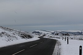
 Scrubland under snow
 -
 Eglwyseg valley from Horseshoe Pass
 -
 Sheep in a lay-by
 -
 View north-east from pass
 -
 View south-east from pass


.jpg)


References
- ^ "New 40mph limit on Horseshoe Pass is approved". Saffy Sprocket. 18 January 2022. Retrieved 18 January 2022.
- Llandegla Millennium Action Group (2003) Llandegla Then and Now, LMAG, Llandegla.
External links
- Historic Landscape Characterisation - The Vale of Llangollen: Maesyrychen, Clwyd-Powys Archaeological Trust
- Horseshoe Pass walk, BBC
- HorseShoe Pass Denbighshire, Positively North Wales
This Denbighshire location article is a stub. You can help Wikipedia by expanding it. |