
Humphrey Head
Since 1906 it has been the home of Humphrey Head Outdoor Centre, currently operated by Mere Mountains.[1] Most of the Head is a nature reserve, managed by Cumbria Wildlife Trust since 1992 although still owned by the Holker Estate.[2] On the eastern flank is a wood with permitted rights of way. It used to be possible to walk to the end of the outcrop by walking on the sands to the west of Humphrey Head, but changes in the sands have rendered this difficult (although still possible in wellies) (2011). To the east of Humphrey Head is a marsh which forms part of Kents Bank.
Humphrey Head is the traditional location for the killing of the last wolf in England, in about 1390. Folklore has it that the wolf descended the fells from near Coniston where it had caused havoc among the sheep flocks. After it attacked a child in Cark the country-folk chased it to the end of Humphrey Head where it was killed with pikes while hiding among the rocks.
Below Humphrey Head there used to be house with a spring. The water was reputed to have therapeutic properties. Miners from Durham used to walk here just to take the water. All that is now left is a rusting lead pipe and a clear trickle of water.
On the rock face lies a memorial to William Pedder who died in August 1857, it reads:
Beware how you these Rocks ascend
Here WILLIAM PEDDER met his end
August 22nd 1857 Aged 10 years.
By permission
Humphrey Head is the subject of a chapter of Wainwright's book The Outlying Fells of Lakeland,[3] although he says "Not by any exercise of the imagination can Humphrey Head be classed as an outlying fell of Lakeland" as although it is "outlying", the summit is 172 feet (52 m) and "a fell it is certainly not". He describes a walk from Kents Bank railway station.
-
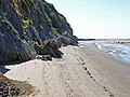 Humphrey Head beach below the cliffs which provide the only sea level traverse in the Lake District area, also popular with walkers but there is a high risk of sinking sands and incoming tides.
 -
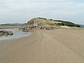 Humphrey Head seen from the sands
 -
 from the cave
 -
 Nature Reserve Map
 -
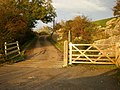 Entrance to Humphrey Head Outdoor Centre, hidden away out of sight of the road


References
- ^ "Humphrey Head: an amazing base for Outdoor Learning". Mere Mountains. Retrieved 30 June 2021.
- ^ "Humphrey Head - Cumbria Wildlife Trust". Archived from the original on 1 November 2012. Retrieved 24 January 2013.
- ^ Wainwright, A. (1974). "Humphrey Head". The Outlying Fells of Lakeland. Kendal: Westmorland Gazette. pp. 66–69.
- "Townships - Lower Allithwaite". British History Online. Retrieved 26 August 2009.
- William Colin Campbell Rose, Sir Kingsley Charles Dunham, Geological Survey of Great Britain (1977). Geology and hematite deposits of South Cumbria: economic memoir for 1:50 000 geological sheet 58, and southern part of sheet 48, Geological Survey of Great Britain Memorial Series. H.M.S.O. ISBN 978-0-11-880780-7.)
{{cite book}}: CS1 maint: multiple names: authors list (link - Mrs Jerome Mercier (1900). The Last Wolf: A Story of England in the Fourteenth Century. HT Mason, Grange-over-Sands. ASIN B000Z4DXM8.