
Hypsometric tints
Hypsometric tints (also called layer tinting, elevation tinting, elevation coloring, or hysometric coloring) are colors placed between
History
In his map of central Italy, c.1503, Leonardo da Vinci introduced the cartographic convention of using colored chalk to indicate changes in elevation.[1][2]

In the 18th century,
At right is "The very earliest rendition of a bathymetric map of an oceanic basin. Matthew Fontaine Maury published this map in 1853 in Explanations and Sailing Directions to Accompany the Wind and Current Charts."[4]
Application

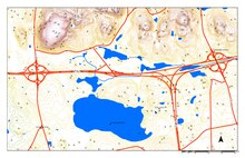
There are two primary types of hypsometric tinting: discrete and continuous.
Maps with discrete hypsometric tinting have a distinct, uniform color between each of the contours, which give them a stepped appearance. The historical bathymetric map shown at the right is an example of discrete hypsometric tinting.
In a map with continuous hypsometric tinting, there is a gradual shift from one tint to another, which presents a smoother appearance. This is often accomplished using data from a digital elevation model (DEM). Each pixel in the DEM is assigned a color which corresponds to the exact elevation at that location, so it is more precise than discrete hypsometric tinting.[5] The colorful image of the moon has continuous hypsometric tinting.
A typical color scheme progresses from dark greens for lower elevations, up through yellows/browns and on to grays and white at the highest elevations. Similar to
Some cartographers have suggested that hypsometric tints are often used as decoration, rather than for informational purposes:[7]
...the current popularity of hypsometric tints has more to do with production ease and pretty colors than it does with our interest in elevation. ... With hypsometric tints, the result is often a map with pleasing colors that blend softly into one another in an orderly fashion, a design trait that people find attractive, even if they don't necessarily know or care about elevations.
References
- ^ Royal Collection - A map of central Italy (Leonardo da Vinci)
- ^ Claim of da Vinci's first use
- doi:10.14714/CP69.20.
- ^ NOAA Ocean Explorer: First bathymetric map printed
- OCLC 60396792.
- ^ Buckley, Alileen. Hysometric tinting "ArcGIS Resource Center Blog". Esri 9 May 2008. Accessed 20 December 2017
- ^ Patterson, T. and Vaughn Kelso, K. (2004). Hal Shelton Revisited: Designing and Producing Natural-Color Maps with Satellite Land Cover Data. Cartographic Perspectives, 47. p. 9