
Inishsirrer
Native name: Inis Oirthir[1] | |
|---|---|
 NW half of the island from a flight preparing to land at Donegal Airport | |
 Inishsirrer | |
| Geography | |
| Location | Atlantic Ocean |
| Coordinates | 55°06′54″N 8°19′55″W / 55.11500°N 8.33194°W |
| Area | 0.43 km2 (0.17 sq mi)[2] |
| Length | 1.6 km (0.99 mi) |
| Width | 0.4 km (0.25 mi) |
| Administration | |
| Province | Ulster |
| County | Donegal |
| Demographics | |
| Population | 0 |
Inishsirrer (Irish: Inis Oirthir, meaning 'outer island[3]') is a small island and a townland off the coast of Gweedore, County Donegal, Ireland.
Geography
Inishsirrer is around 1 kilometre (0.6 miles) off the coast of Gweedore, not faraway from Inishmeane. It is around 1.6 kilometres (1.0 mile) long and four hundred metres (1,300 feet) wide.[citation needed]
History
A small community used to live on Inishsirrer in the first part of the 20th century, but today the island is uninhabited and its old buildings are mostly ruined.[4]
|
|
| ||||||||||||||||||||||||||||||||||||||||||||||||||||||||||||||||||||||||||||||
| Source: Central Statistics Office. "CNA17: Population by Off Shore Island, Sex and Year". CSO.ie. Retrieved 12 October 2016. | ||||||||||||||||||||||||||||||||||||||||||||||||||||||||||||||||||||||||||||||||
Fishing
Inishsirrer was known as a good spot for lobster fishing.[5]
See also
References
- ^ "Inis Oirthir". Placenames Database of Ireland. Dublin City University. Retrieved 25 February 2016.
- ISBN 9780806310527. Retrieved 25 February 2016.
- ISBN 9781900935319. Retrieved 25 February 2016.
- ^ "The Lonely Homes of Inishsirrer". PhotosOfDonegal.com. Retrieved 18 April 2021.
- ISBN 9780850451689. Retrieved 25 February 2016.
Image gallery
-
 Old buildings
 -
 View from a beach near Glassagh
 -
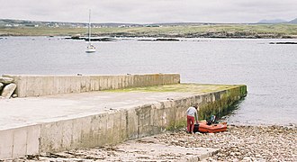 A jetty on the island
 -
 The deserted village


External links
![]() Media related to Inishsirrer at Wikimedia Commons
Media related to Inishsirrer at Wikimedia Commons
