
Jevnica
Jevnica | |
|---|---|
 | |
 Jevnica Location in Slovenia | |
| Coordinates: 46°4′58.16″N 14°43′52.25″E / 46.0828222°N 14.7311806°E | |
| Country | |
| Traditional region | Lower Carniola |
| Statistical region | Central Sava |
| Municipality | Litija |
| Area | |
| • Total | 1.82 km2 (0.70 sq mi) |
| Elevation | 272.7 m (894.7 ft) |
| Population (2002) | |
| • Total | 367 |
| [1] | |
Jevnica (pronounced railway line from Ljubljana to Zidani Most runs through the settlement. The area is part of the traditional region of Lower Carniola. It is now included with the rest of the municipality in the Central Sava Statistical Region; until January 2014 the municipality was part of the Central Slovenia Statistical Region.[2]
Name
Jevnica was first attested in written sources in 1449 as an der Gelnicz. The settlement is probably named after Jevnica Creek, a
assimilation at a distance
.
History
At the beginning of the 20th century, Jevnica had only three houses and was a hamlet of
Styria. Many of the residents joined the Partisan movement on 6 January 1943. A plaque on the Pintar house states that the woman living there burned to death when German forces burned the house in November 1944. A community center with a store, bar, and hall was built in Jevnica in 1948.[4]
Gallery
-
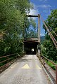 Covered bridge over the Sava River in Jevnica

References
- ^ Statistical Office of the Republic of Slovenia Archived 18 November 2008 at the Wayback Machine
- ^ Municipality of Litija website
- ^ a b Snoj, Marko (2009). Etimološki slovar slovenskih zemljepisnih imen. Ljubljana: Modrijan. p. 179.
- ^ a b Savnik, Roman (1971). Krajevni leksikon Slovenije, vol. 2. Ljubljana: Državna založba Slovenije. p. 266.
External links
 Media related to Jevnica at Wikimedia Commons
- Jevnica on Geopedia

| International | |
|---|---|
| National | |