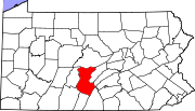
Juniata Township, Huntingdon County, Pennsylvania
Juniata Township, Huntingdon County, Pennsylvania | |
|---|---|
814 | |
| FIPS code | 42-061-38608 |
| Local phone exchanges: 641, 643, 644 | |
Juniata Township is a township that is located in Huntingdon County, Pennsylvania, United States. The population was 433 at the time of the 2020 census.[2]
Geography
According to the United States Census Bureau, the township has a total area of 20.1 square miles (52 km2), of which 16.5 square miles (43 km2) is land and 3.6 square miles (9.3 km2) (17.85%) is water.
Adjacent Municipalities
All municipalities are located in Huntingdon County unless otherwise noted.
Demographics
| Census | Pop. | Note | %± |
|---|---|---|---|
| 2000 | 553 | — | |
| 2010 | 554 | 0.2% | |
| 2020 | 433 | −21.8% | |
| 2022 (est.) | 425 | [2] | −1.8% |
| U.S. Decennial Census[3] | |||
At the
The population density was 33.6 inhabitants per square mile (13.0/km2). There were 451 housing units at an average density of 21.3/sq mi (8.2/km2).
The
There were 235 households; 26.0% had children under the age of eighteen living with them, 67.0% were married couples living together, 3.6% had a female householder with no husband present, and 26.8% were non-families. 23.2% of households were made up of individuals, and 9.8% were one-person households with a resident aged sixty-five or older.
The average household size was 2.46 and the average family size was 2.87.
The age distribution was 18.4% under the age of eighteen, 2.2% from eighteen to nineteen, 5.4% from twenty to twenty-four, 6.9% from twenty-five to thirty-four, 19.9% from thirty-five to forty-nine, 25.3% from fifty to sixty-four, and 22.0% who were aged sixty-five or older. The median age was forty years. The population was 49.10% male, and 50.90% female.
References
- ^ "2016 U.S. Gazetteer Files". United States Census Bureau. Retrieved August 14, 2017.
- ^ a b c d Bureau, US Census. "City and Town Population Totals: 2020-2022". Census.gov. US Census Bureau. Retrieved January 31, 2024.
- ^ "Census of Population and Housing". Census.gov. Retrieved June 4, 2016.
- ^ "U.S. Census website". United States Census Bureau. Retrieved January 31, 2008.

