Juniville
You can help expand this article with text translated from the corresponding article in French. (December 2008) Click [show] for important translation instructions.
|
Juniville | |
|---|---|
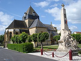
 The church and war memorial in Juniville | |
| Coordinates: 49°23′54″N 4°23′00″E / 49.3983°N 4.3833°E | |
| Country | France |
| Region | Grand Est |
| Department | Ardennes |
| Arrondissement | Rethel |
| Canton | Château-Porcien |
| Intercommunality | Pays Rethélois |
| Government | |
| • Mayor (2020–2026) | Christian Cogniard[1] |
| Area 1 | 26.2 km2 (10.1 sq mi) |
| Population (2021)[2] | 1,239 |
| • Density | 47/km2 (120/sq mi) |
| Time zone | UTC+01:00 (CET) |
| • Summer (DST) | UTC+02:00 (CEST) |
| INSEE/Postal code | 08239 /08310 |
| Elevation | 88–147 m (289–482 ft) (avg. 99 m or 325 ft) |
| 1 French Land Register data, which excludes lakes, ponds, glaciers > 1 km2 (0.386 sq mi or 247 acres) and river estuaries. | |
Juniville (French pronunciation: [ʒynivil]) is a commune in the Ardennes department and Grand Est region of north-eastern France.
Population
| Year | Pop. | ±% p.a. |
|---|---|---|
| 1968 | 718 | — |
| 1975 | 720 | +0.04% |
| 1982 | 760 | +0.78% |
| 1990 | 829 | +1.09% |
| 1999 | 844 | +0.20% |
| 2009 | 1,214 | +3.70% |
| 2014 | 1,206 | −0.13% |
| 2020 | 1,247 | +0.56% |
| Source: INSEE[3] | ||
Personalities
- The poet Paul Verlaine rented a room in Juniville in the 1880s, close to the farm where his pupil Lucien Létinois lived. The village inn has been restored and turned into a museum dedicated to Verlaine.
See also
References
- ^ "Répertoire national des élus: les maires" (in French). data.gouv.fr, Plateforme ouverte des données publiques françaises. 13 September 2022.
- ^ "Populations légales 2021". The National Institute of Statistics and Economic Studies. 28 December 2023.
- ^ Population en historique depuis 1968, INSEE
External links
Wikimedia Commons has media related to Juniville.
- (in French) Official site


