
Kōyasan chōishi-michi
高野山町石道 | |
| Region | Kansai region |
|---|---|
| Type | Pilgrimage route |
| History | |
| Founded | 1285 |
| Periods | Kamakura period |
| Site notes | |
| Public access | Yes |
| Type | Cultural |
| Criteria | ii, iii, iv, vi |
| Designated | 2004 |
Kōyasan chōishi-michi (高野山町石道) is a pilgrimage route on the
Route
The Kōyasan chōishi-michi is claimed to be the route created by
History
The guideposts were originally wooden, and had to be frequently replaced due to exposure to the elements. During the Kamakura period, a priest of Mount Kōya obtained donations from the Imperial Family and a number of leading warlords, and began replacing these wooden markers with granite five-tiered stupas over a 20 year period, with the project completed in 1285. They are engraved with their number in the sequence from Danjō Garan, as well as the seed syllable of one of the divinities in the Taizōkai Mandala, for the first 180, or the Kongōkai Mandala, for the remainder,[5]along with the name of the donor, the date, and the votive purpose of the donor. Of the original 216 guideposts, 179 remain in situ.[1]
Gallery
-
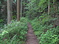 Kōyasan chōishi-michi
 -
 Chōishi No.1


See also
- List of Historic Sites of Japan (Wakayama)
- Kumano Kodō
- Sacred Sites and Pilgrimage Routes in the Kii Mountain Range
- The 100 Views of Nature in Kansai
References
- ^ ICOMOS. Retrieved 8 May 2011.
- ^ "Wakayama Prefectural Parks" (PDF). Wakayama Prefecture. Archived from the original (PDF) on 20 July 2011. Retrieved 8 May 2011.
- ^ "Database of National Cultural Properties". Agency for Cultural Affairs. Retrieved 8 May 2011.
- ^ "Pilgrimage Route". Wakayama Tourism Federation. Archived from the original on 23 July 2011. Retrieved 8 May 2011.
- ^ ISBN 978-0-7914-7259-0.
External links
- Chōishi-michi - homepage Archived 2011-08-13 at the Wayback Machine(in Japanese)
- Chōishi-michi - Map(in Japanese)