
Kaapsehoop
This article needs additional citations for verification. (April 2011) |
Kaapschehoop (Kaapsehoop) | |
|---|---|
UTC+2 (SAST ) |
Kaapschehoop or Kaapsehoop is a village situated in Mpumalanga province (formerly Eastern Transvaal) of South Africa.
It is situated 1640 m (5380 ft.) above sea level on the Drakensberg Highveld escarpment, about 28 km from Mbombela (also known as Nelspruit), the capital of Mpumalanga. The name of the village was derived from gold discoveries in and around the area. The find created hope for the early inhabitants of the De Kaap Valley (The Cape Valley) below, it offered the chance of attaining great wealth.
Today Kaapschehoop is a scenic mountain top village with vibrant arts & crafts shops, confectionaries, restaurants, pubs and accommodation. It is surrounded with expansive views, nature reserves, golden grass land, wild flowers, pine plantations, unique sandstone formations, flowing streams, and unique endangered wildlife. Kaapschehoop village is set out between large natural clearings in the rock fields near the top of the escarpment overlooking the lush
History
-
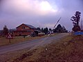 Entrance to Kaapsehoop
 -
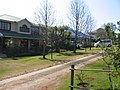 Kaapsehoop streetscape
 -
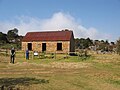 Mining Commissioner's House 1884 Kaapsehoop


Kaapsehoop originally gained fame as a
-
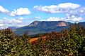
 Edge of escarpment overlooking De Kaap valley
 -
 The Kaapsehoop heights seen from below
 -
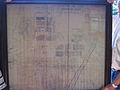 Old Surveyor General Map of Kaapsche Hoop showing diggings area crossed out


The town has been "re-discovered" in recent time and has now become a popular weekend retreat with its period housing including accommodation establishments. New housing (some not period) has also been established on some of the remaining vacant stands (erven). The town is also within commuting distance of the centre of Mbombela situated some 30 odd kilometres away.
The rock field formations near the town are made up of
Origin of the name
Kaapschehoop has had multiple names and spellings since 1874 and the discovery of gold. Kaapsche Hoop is the original Dutch spelling of Kaapsehoop as now spelled in Afrikaans.
It was first known as Duiwels Kantoor (Devils Office) and later changed to Kaapsche Hoop (Cape Hope) due to objections by the church that the former was considered a "heathen" name by the standards of the time.
The village is sometimes referred to in past documents as De Kaap (The Cape) because of its landmass jutting into De Kaap valley (The Cape valley). The valley often fills with cloud, resulting in the image of a costal cape jutting out into the ocean.
Marthinus Wessel Pretorius of the Transvaal Repbublic, when visiting Duiwels Kantoor, was reminded of the view from Table Mountain. Encouraged by the discoveries of gold, he renamed the settlement to Kaapsche Hoop in 1886.
The name of the town was no doubt derived from the fact that gold was discovered in the town which sits high above the De Kaap Valley (The Cape Valley) and the find then created the hope for the early inhabitants of the nearby De Kaap Valley area of attaining great wealth.
References
- ^ a b c d "Sub Place Kaapsehoop". Census 2011.
- ^ ‘Memories of the Lowveld’s Eland Valley 1854 -1983’ by Paddy Davies-Webb
- ^ ‘A History of Kaapsehoop – the Forgotten Town’ by Kieren Bailey & Lewis Craig
- ^ ‘Lost Trails Of The Mokhonjwa Mountains‘ by Bernard John Lovell de Souza
- ^ ‘The History Of Mining In the Barberton Greenstone Belt, South Africa, With An Emphasis On Gold (1868 – 2012)’ by Carl R. Anhaeusser
External links
Municipalities and communities of Ehlanzeni District Municipality, Mpumalanga | ||
|---|---|---|
District seat: Nelspruit (Mbombela) | ||
| Mbombela | .svg) | |
| Nkomazi | ||
| Thaba Chweu |
| |
| Bushbuckridge |
| |