
Kalenga
Kalenga
Kata ya Kalenga | |
|---|---|
UTC+3 (EAT) | |
| Postcode[2] | 51201 |
Kalenga is an administrative
Kalenga, which is situated along the side-lines of the Great Ruaha River, is one among the historical villages of "Iringa". It is known for being the residence of the famous Chief Mtwa Mkwawa of the Hehe tribe, who resisted German colonization.[4] Mkwawa fortified the village with a wall 4 meters high and 5 kilometers in circumference.[5] The town was stormed by a German force in 1894, and the fortifications were destroyed. Mkwawa continued to resist until 1898, when he was finally hunted down by the Germans and committed suicide. His head was cut off and sent to Germany, but eventually returned in 1954; his skull is now on display in a small museum in Kalenga.
Villages and vitongoji
The ward has 3 villages and 16 vitongoji.[2]
- Tosamaganga
- Ipamba
- Irangi
- Mabanda
- Tosa kilimani
- Unyangwila
- Kalenga
- Galinoma
- Igawa
- Ilundimembe
- Kidope
- Lipuli
- Maktaba
- Mwambao
- Wangi
- Isakalilo
- Isakalilo A
- Isakalilo B
- Isakalilo C
Gallery
-
 A 1914 map German shows Iringa and its railway station as "Alt-Iringa", nowadays known as Kalenga
 -
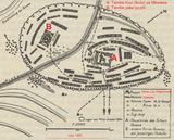 Map (1897) showing the German attack
 -
 Skull of Mkwawa displayed at Kalenga


References
- ^ Dar es Salaam, Tanzania: National Bureau of Statistics. 1 April 2016. Archived(PDF) from the original on 27 December 2021. Retrieved 3 July 2022.
- ^ a b "Iringa Postcodes" (PDF). Tanzania Communications Regulatory Authority. Archived (PDF) from the original on 29 July 2022. Retrieved 17 August 2022.
- Dar es Salaam, Tanzania: National Bureau of Statistics. 1 March 2013. Archived(PDF) from the original on 26 March 2022. Retrieved 3 July 2022.
- ^ Later called by the Germans "Old Iringa", see Deutsches Kolonial-Lexikon, article "Iringa", online here (ger.)
- ISBN 978-0-521-29611-3, page 112
This Iringa Region location article is a stub. You can help Wikipedia by expanding it. |