
Kalpa, Himachal Pradesh
Kalpa | |
|---|---|
Village | |
UTC+5:30 (IST) | |
| PIN | 172108 |
| Vehicle registration | HP-25 |
Kalpa is a small village in the
Geography
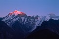
.jpg)
Kalpa is at 31°32′N 78°15′E / 31.53°N 78.25°E.
Overview

Kalpa was known as a Chini village during the colonial and pre colonial period. it was tehsil headquarter during colonial times and later became district headquarter of Kinnaur before it was shifted to Reckong Peo. current Kalpa is a village with a history of ancient temples. The
In Episode 5 of Ice Road Truckers#IRT: Deadliest Roads - Season 1: Himalayas Lisa Kelly and Rick Yemm delivered two images (one each) (well packed with sandbags and sand and straw) of the goddess Kali (shown as treading on her husband Shiva) along a frightful mountain road hacked out of cliffsides to a temple at Kalpa.
Demography

Kalpa has an average literacy rate of 83.75%.
Religion
Hinduism is the main religion in the district followed by Tibetan Buddhism. These two religions have undergone religious mixing, along with some indigenous shamanistic practices.
Places of interest
Reckong Peo : Located 260 km from Shimla, 7 km from Powari and 8 km from Kalpa. Reckong Peo is the headquarters of district Kinnaur.
Kothi Temple: Just 3 km from Reckong Peo. Kothi has a temple dedicated to the goddess Chandika Devi. Set against a backdrop of mountains and groves of the deodar the temple has an unusual architectural style and fine sculpture. An exquisite gold image of goddess is enshrined in sanctum.
The Chaka Meadows: is an easy hike of 3-4 kilometres. The trail starts from a point on Kalpa - Roghi road. Chaka meadows (alt. 3800 m) offers splendid views of the Kinnaur Kailash mountain range.[3]
Rolla Dokhang: It is a selfie point located on Kalpa-Roghi road (about 3 km away from Chini Market). This rocky outcrop offers some great views of the Kinnaur Kailash mountain range, Satluj river gorge and Roghi, Mebar and Ralli village. [4]
Agriculture
The region is very famous for production of high-quality apples and pinus gerardiana, also known as chilghoza. All of tehsil Kalpa is apple growing area, the primary crop for residents of the area. Kalpa is surrounded by Deodar, apple, and pinus gerardiana chilghoza trees.
Climate
All of Kalpa enjoys a temperate climate due to its high elevation, with long winters from October to May, and short summers from June to September. In winter, all the villages are covered by about 5–7 feet of snow, and the temperature can drop to as low as -20 °C. Warm clothing may be necessary even in the summer.
| Climate data for Kalpa, Himachal Pradesh (1984–2010, extremes 1984–2011) | |||||||||||||
|---|---|---|---|---|---|---|---|---|---|---|---|---|---|
| Month | Jan | Feb | Mar | Apr | May | Jun | Jul | Aug | Sep | Oct | Nov | Dec | Year |
| Record high °C (°F) | 16.1 (61.0) |
18.1 (64.6) |
24.4 (75.9) |
25.2 (77.4) |
28.6 (83.5) |
30.7 (87.3) |
27.8 (82.0) |
28.3 (82.9) |
28.3 (82.9) |
24.6 (76.3) |
24.5 (76.1) |
19.0 (66.2) |
30.7 (87.3) |
| Mean daily maximum °C (°F) | 5.2 (41.4) |
6.5 (43.7) |
11.1 (52.0) |
16.6 (61.9) |
20.4 (68.7) |
22.8 (73.0) |
22.7 (72.9) |
22.2 (72.0) |
21.0 (69.8) |
18.2 (64.8) |
14.3 (57.7) |
8.8 (47.8) |
15.8 (60.4) |
| Mean daily minimum °C (°F) | −4.0 (24.8) |
−3.0 (26.6) |
0.3 (32.5) |
3.9 (39.0) |
6.8 (44.2) |
10.2 (50.4) |
12.8 (55.0) |
12.6 (54.7) |
9.3 (48.7) |
4.2 (39.6) |
1.2 (34.2) |
−1.5 (29.3) |
4.4 (39.9) |
| Record low °C (°F) | −15.4 (4.3) |
−11.0 (12.2) |
−8.2 (17.2) |
−3.5 (25.7) |
−0.5 (31.1) |
3.5 (38.3) |
6.0 (42.8) |
5.8 (42.4) |
3.0 (37.4) |
−3.6 (25.5) |
−5.5 (22.1) |
−8.6 (16.5) |
−15.4 (4.3) |
| Average rainfall mm (inches) | 139.6 (5.50) |
99.4 (3.91) |
197.7 (7.78) |
75.6 (2.98) |
67.6 (2.66) |
30.2 (1.19) |
46.8 (1.84) |
45.5 (1.79) |
63.5 (2.50) |
31.8 (1.25) |
27.9 (1.10) |
52.3 (2.06) |
878.0 (34.57) |
| Average rainy days | 5.9 | 6.8 | 8.2 | 5.7 | 5.5 | 2.5 | 4.8 | 5.2 | 4.7 | 1.8 | 1.4 | 3.4 | 55.7 |
| Average relative humidity (%) (at 17:30 IST )
|
43 | 48 | 42 | 40 | 44 | 50 | 65 | 69 | 62 | 44 | 36 | 36 | 49 |
| Source: India Meteorological Department[5][6] | |||||||||||||
Food habits
The staple foods are wheat, ogla, phafra, and barley, all local produce. Besides these, kankani, cheena, maize, chollair and bathu are also common. The principal pulses consumed are peas, black peas, mash and rajmash. The vegetables usually consumed are cabbage, turnips, peas, beans, pumpkin, potato, okra and tomato besides some locally available wild greens. Also popular is rice, which is imported from the plains. A salted tea in the morning and evening is very popular among the Kinnauris, usually taken along with sattu made of parched barley flour. People are non-vegetarian and eat goat and ram's meat. Alcoholic drinks in day-to-day life and also on ceremonial or festive occasions are quite common. Alcohol is distilled at the household level. It is made out of locally grown fruits like grapes, apple, and pears, as well as from barley.
Lifestyle
Generally, Kinner houses have storerooms for keeping grain and
Gallery
-
 Kalpa and Kinnaur Kailash during monsoon weather
 -
 Wood work at main Entrance of Hindu Temple at Kalpa
 -
 Hindu Temple at Kalpa
 -
 Kinnaur Kailash from Kalpa
 -
 Kinner Kailash Resort Kalpa
 -
 Kinner Kailash range form Kalpa


References
- ^ "India's first voter Shyam Saran Negi casts his vote at Kalpa".
- ^ Falling Rain Genomics, Inc - Kalpa
- ^ "Chaka meadows hike". Raacho Trekkers.
- ^ "Beauty And Hardships Of Life in Kinnaur & Spiti Valley During Winter". Raacho Trekkers.
- ^ "Station: Kalpa Climatological Table 1981–2010" (PDF). Climatological Normals 1981–2010. India Meteorological Department. January 2015. pp. 381–382. Archived from the original (PDF) on 5 February 2020. Retrieved 15 February 2020.
- ^ "Extremes of Temperature & Rainfall for Indian Stations (Up to 2012)" (PDF). India Meteorological Department. December 2016. p. M69. Archived from the original (PDF) on 5 February 2020. Retrieved 15 February 2020.