Kara Dag Mountain
| Karadag | |
|---|---|
 | |
| Highest point | |
| Elevation | 577 m (1,893 ft) |
| Coordinates | 44°55′53″N 35°13′22″E / 44.9314°N 35.2228°E |
| Naming | |
| Native name |
|
| Geography | |
| Location | Crimea, Ukraine |
| Parent range | Crimean Mountains |
| Geology | |
| Age of rock | 172.8 ± 4.5 Ma [1] |
The Karadag (
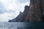
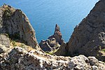
rock formation which rises to a height of 577 meters between the Crimean coastal town of Köktöbel and the Otuz river valley. It has been the site of a marine biological station since the early 20th century. Some 2874 ha of coastline and 809 ha of coastal waters have been protected as the Karadag Nature Reserve since 1979. The littoral is rich in picturesque cliffs such as the Devil's Gate. The best views of the Karadag are from Köktöbel and Kurortne
.
Gallery
-
Karadag cliffs
-
Karadag coastline
-
Karadag cliffs by the sea
-
View from the top
-
View from the top
See also
References
- S2CID 133753885.
External links
Wikimedia Commons has media related to Kara-Dag.
- http://www.blacksea-crimea.com/Places/Kara-Dag.html
- https://web.archive.org/web/20070711091427/http://www.tourism.crimea.ua/eng/dostoprim/parks/reserves/kardagvr/index.html
- http://www.tour.crimea.com/ENGLISH/NAVIGATOR/ABOUT_CRIMEA/geography.shtml


