
Karaj River
This article needs additional citations for verification. (February 2022) |

The Karaj (Persian: رودخانه کرج) is a river on the central plateau of Iran.[1] It is the second largest river after Zayandarud in the central plateau region.[1]
About
The Karaj runs roughly 152 miles (245 km) in length.Qom Province.
The Amir Kabir Dam is constructed across the river in the foothills of the Alborz mountain range.
Gallery
-

-

-
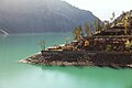 Amir Kabir Dam
 -
 Amir Kabir Dam
 -
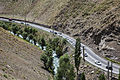 Chalus road - Ninara
 -
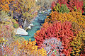 Karaj River in Adaran
 -
 Karaj River
 -
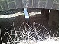 Narrow Karaj River channel under bridge


References
- ^ a b c Hourade, Bernard (December 15, 2010). "Karaj River". iranicaonline.org. Encyclopaedia Iranica Foundation. Retrieved 2022-02-04.
34°46′50″N 51°49′51″E / 34.78056°N 51.83083°E
| Lake Urmia basin | |
|---|---|
| Persian Gulf basin | |
Oman sea basin | |
| Caspian basin |
|
| Gavkhouni basin | |
| Namak Lake basin |
|
| Hamun-e Jaz Murian basin | |
| Other | |