Kasagi, Kyoto
Kasagi
笠置町 | |
|---|---|
Town | |
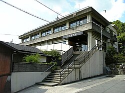
 Kasagi Town Hall | |
 Location of Kasagi in Kyoto Prefecture | |
 | |
| Coordinates: 34°45′38″N 135°56′22″E / 34.76056°N 135.93944°E | |
| Country | Japan |
| Region | Kansai |
| Prefecture | Kyoto |
| District | Sōraku |
| Area | |
| • Total | 23.52 km2 (9.08 sq mi) |
| Population (April 1, 2024) | |
| • Total | 1,108 |
| • Density | 47/km2 (120/sq mi) |
| Time zone | UTC+09:00 (JST) |
| City hall address | 90-1 Kasagi Nishi-dori, Kasagi-machi, Soraku-gun, Kyoto-fu 619-1303 |
| Website | Official website |
| Symbols | |
| Bird | Japanese bush warbler |
| Flower | Prunus × yedoensis |
| Tree | Rhododendron |

Kasagi (笠置町, Kasagi-chō) is a town in Sōraku District, Kyoto Prefecture, Japan. As of 1 April 2024[update], it has a population of 1,108 in 579 households[1] and a population density of 47 persons per km2. The total area of the town is 23.52 square kilometres (9.08 sq mi). It has the smallest population of any municipality in Kyoto.
Geography
Kasagi is located in far southern Kyoto Prefecture. Forests occupy 80% of the total area, with the Kizugawa River flowing through the center of the town, the Nunome River and the Uchitaki River flowing from the south, and the Yokogawa River from the north. The town also enclaves scattered in the eastern part of the Kamo district of Kizugawa city. Parts of the town are within the borders of the Kasagiyama Prefectural Natural Park.
Neighboring municipalities
- Kizugawa
- Wazuka
- Minamiyamashiro
- Nara
Climate
Kasagi has a humid subtropical climate (Köppen Cfa) characterized by warm summers and cool winters with light to no snowfall. The average annual temperature in Kasagi is 13.7 °C. The average annual rainfall is 1439 mm with September as the wettest month. The temperatures are highest on average in August, at around 25.7 °C, and lowest in January, at around 2.1 °C.[2]
Demographics
Per Japanese census data,[3] the population of Kasagi has declined in recent decades.
| Year | Pop. | ±% |
|---|---|---|
| 1940 | 2,595 | — |
| 1950 | 3,323 | +28.1% |
| 1960 | 3,048 | −8.3% |
| 1970 | 2,721 | −10.7% |
| 1980 | 2,506 | −7.9% |
| 1990 | 2,311 | −7.8% |
| 2000 | 2,056 | −11.0% |
| 2010 | 1,626 | −20.9% |
| 2020 | 1,144 | −29.6% |
History
The area of Kasagi was part of ancient
Government
Kasagi has a
Economy
Kasagi is a rural area, with an economy based on agriculture and forestry.
Local attractions

- Shingon sect Buddhist temple said to have been founded by Emperor Kōbun or Emperor Tenmu. Historically it has had close relations with Tōdai-ji and Kōfuku-ji in Nara. It is an important temple in the history of Buddhism in Japan, and many eminent monks have served as abbot. According to legend, the annual Omizutori ceremony at Tōdai-ji was begun by the monk Jitchū after he discovered a passage here that led to the heavenly home of Maitreya.
Education
Kasagi has one public elementary school and one public junior high school operated by the Sōraku Tōbu kōiki rengō. The town does not have a high school
Transportation
Railway
Highways
References
External links
- Kasagi official website (in Japanese)
 Media related to Kasagi, Kyoto at Wikimedia Commons


