
Kata Tjuta
| Kata Tjuṯa / Mount Olga | |
|---|---|
Pitjantjatjara) | |
| Geography | |
 Kata Tjuṯa / Mount Olga  Kata Tjuṯa / Mount Olga Kata Tjuṯa / Mount Olga (Australia) |

Kata Tjuṯa (
The 36 domes that make up Kata Tjuṯa / Mount Olga cover an area of 21.68 km2 (8.37 sq mi) are composed of conglomerate, a sedimentary rock consisting of cobbles and boulders of varying rock types including granite and basalt, cemented by a matrix of coarse sandstone. The highest dome, Mount Olga, is 1,066 m (3,497 ft) above sea level, or approximately 546 m (1,791 ft) above the surrounding plain (198 m (650 ft) higher than Uluṟu).[1] Kata Tjuṯa is located at the eastern end of the Docker River Road.
Name
The other name, The Olgas, comes from the tallest peak, Mount Olga. At the behest of Baron Ferdinand von Mueller, Mount Olga was named in 1872 by Ernest Giles, in honour of Queen Olga of Württemberg (born Grand Duchess Olga of Russia, daughter of Tsar Nicholas I). She and her husband, King Charles I of Württemberg, had marked their 25th wedding anniversary the previous year by, among other things, naming Mueller a Freiherr (baron), making him Ferdinand von Mueller. The naming was his way of repaying the compliment.[5]
On 15 December 1993, a dual naming policy was adopted that allowed official names consisting of both the traditional Aboriginal name and the English name. As a result, Mount Olga was renamed Mount Olga / Kata Tjuṯa. On 6 November 2002, following a request from the Regional Tourism Association, the order of the dual names was officially reversed, to Kata Tjuṯa / Mount Olga.[6]
Geologic origin
The region surrounding Kata Tjuṯa lies in the
Both Uluṟu and Kata Tjuṯa are made of sediment originating in this Mount Currie Conglomerate and both have a chemical composition similar to granite. Scientists using
Legends
There are many
Locations, access and facilities
Kata Tjuṯa / Mount Olga can be reached via Ayers Rock Airport, followed by a 55-kilometre (34 mi) drive south, then west. Visitors are required to pay an entry fee.[10] Kata Tjuṯa is about 495 kilometres (308 mi) by road from Alice Springs, via the Stuart and Lasseter highways. It is a 4+1⁄2 hour drive.
Kata Tjuṯa / Mount Olga has both a sunrise and sunset viewing area, which are accessible via a short walk from Kata Tjuṯa Road.[11] There are also two walks that enter the domes of Kata Tjuta:
- Valley of the Winds - 7.4km 7.4 km (4.6 mi) / 3-4 hours (Grade 4)[12][13]
- Walpa Gorge walk - 2.6km 2.6 km (1.6 mi) / 1-2 hours[14]
Gallery
-
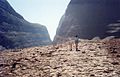
 In the Valley of the Winds walk at Kata Tjuṯa / Mount Olga.
 -
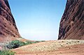
 Kata Tjuṯa / Mount Olga.
 -
 Astronaut photo of Kata Tjuṯa / Mount Olga.
 -
 In Uluṟu-Kata Tjuṯa National Park
 -
 Kata Tjuṯa / Mount Olga, Australia


See also
- Ernest Giles
- Protected areas of the Northern Territory
- Recognition of sacred sites
- Tietkens expedition of 1889
References
- ^ a b Uluṟu-Kata Tjuṯa National Park Visitors Guide. Retrieved 26 April 2013
- ^ "Kata Tjuta". Peakbagger. Retrieved 15 March 2023.
- ^ "Kata Tjuta / Mount Olga". Northern Territory Place Names Register. Northern Territory Government. 6 November 2002. Retrieved 6 March 2023.
- ^ a b Engels, Christoph (2010). 1000 Sacred Places. Tandem Verlag GmbH.
- ^ Whitlam Institute, University of Western Sydney Archived 2005-07-19 at the Wayback Machine. Retrieved 28 March 2007
- ^ Northern Territory Government — NT Place Names Register. Retrieved 17 November 2007
- ^ "Department of Agriculture, Water and the Environment". Department of Agriculture, Water and the Environment.
- ISBN 978-90-481-3054-2
- ISBN 0-89577-087-3.
- ^ "Passes and permits". Parks Australia. Retrieved 2017-09-28.
- ^ "Sunrise and sunset". Parks Australia. Retrieved 2020-11-01.
- ^ "Valley of the Winds walk". Parks Australia. Retrieved 2020-11-01.
- ^ "Valley of the Winds track notes". Hiking the World. Retrieved 2020-11-02.
- ^ "Walpa Gorge Walk". Parks Australia. Retrieved 2020-11-01.
External links
- Uluṟu-Kata Tjuṯa National Park - Australian Department of the Environment and Water Resources
- A Report on the Uluṟu-Kata Tjuṯa National Park
- Uluṟu-Kata Tjuṯa park on Parks Australia (Australian Government)