
Kendalia, Texas
Kendalia, Texas | ||
|---|---|---|
ZIP codes 78027 | ||
| GNIS feature ID | 1339027[1] | |
Kendalia is an unincorporated community in northeastern Kendall County, Texas, United States. It is part of the Texas-German belt.
Geography
Kendalia lies at the intersection of
Metropolitan Statistical Area
.
History
Likely named for early nearby settler George Wilkins Kendall, the community was surveyed in 1883, although a post office was not established until 1895. The local economy has long been dependent primarily on
San Antonio.[6]
-
 Kendalia sign on Ranch to Market Road 473 looking south
 -
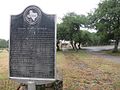 George Wilkins Kendall state historical marker
 -
 Kendalia Library on Ranch to Market Road 473
 -
 Elbel Building


.jpg)
Major highways
- Ranch to Market Road 473
- Farm to Market Road 3351
References
- ^ a b U.S. Geological Survey Geographic Names Information System: Kendalia, Texas. Retrieved on May 12, 2017.
- ^ Rand McNally. The Road Atlas '08. Chicago: Rand McNally, 2008, pp. 100-101.
- ^ U.S. Geological Survey Geographic Names Information System: Kendalia, Texas
- ^ Zip Code Lookup
- ^ "U.S. Census website". United States Census Bureau. Retrieved January 31, 2008.
- ^ Kendalia, Texas, Handbook of Texas Online, 2008-01-17. Accessed 2008-09-26.
External links
Municipalities and communities of Kendall County, Texas, United States | ||
|---|---|---|
| Cities | 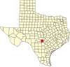 | |
| CDP | ||
| Other communities | ||
| Ghost towns | ||
| Footnotes | ‡This populated place also has portions in an adjacent county or counties | |
| ||
 | This article about a location in Kendall County, Texas is a stub. You can help Wikipedia by expanding it. |