
Kerlingarfjöll
| Kerlingarfjöll | |
|---|---|
 The peaks of the Kerlingarfjöll area. | |
| Highest point | |
| Elevation | 1,477 m (4,846 ft)[1] |
| Coordinates | 64°39′N 19°15′W / 64.650°N 19.250°W |
| Geography | |
 Kerlingarfjöll Location of Kerlingafjöll within Iceland | |
| Location | Iceland |
| Geology | |
| Mountain type | Central volcano |
 Selected geological features near Kerlingarfjöll (red outline). The Hofsjökull volcanic system is also outlined in red. Other shading shows: calderas, central volcanoes and fissure swarms, subglacial terrain above 1,100 m (3,600 ft), and seismically active areas. Clicking on the image enlarges to full window and enables mouse-over with more detail. | |
Kerlingarfjöll (Icelandic pronunciation: Minerals that have emerged from the hot springs also color the ground yellow, red and green.
The area was known formerly for its summer ski resort, but this was dismantled in 2000. Since 2000, Kerlingarfjöll has been operated as a highland resort, offering accommodation and food services to guests in the area.[3]
On March 17 in 2017 it was reported that the Kerlingarfjöll Mountains and geothermal area were being turned into a nature reserve. Although parts of the place already had protection, a whole 367 km2 (142 sq mi) are to be under the protection of the state of Iceland. There have been thoughts of using the 140 °C (284 °F) hot springs as a geothermal power plant. The area is popular with hiking and the tourists.[4]
There are various half-day and one-day hiking trails in the area.[5]
-
 Kerlingarfjöll as seen from the Kjölur road.
 -
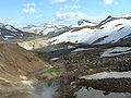 Valley in the Kerlingarfjöll area with geothermal activity.


See also
- Geography of Iceland
- Iceland plume
- Loðmundur, a mountain in Kerlingafjöll
- Volcanism of Iceland
References
- ^ a b c Grönvold, Karl (2019). "Catalogue of Icelandic Volcanoes:Hofsjökull Alternative name: Hofsjökull-Kerlingarfjöll]". Retrieved 2024-04-28.: Detailed Description:1. Geological setting and tectonic context
- ^ .
- ^ "Kerlingarfjöll". Retrieved 2015-06-12.
- ^ "Kerlingarfjöll in the Icelandic highlands to become a reserve". Iceland Monitor.
- ^ "Hiking and Exploring in Kerlingarfjöll in the Highlands of Iceland". Travelade.
External links
- Hiking routes in Kerlingarfjoll
- Description and links to hiking tours Archived 2004-06-24 at the Wayback Machine
| International | |
|---|---|
| Geographic | |