
Kiltan
KİLTON | |
|---|---|
UTC+5:30) | |
| PIN | 682558 |
| Telephone code | 04898 |
| ISO code | IN-LD-08[2] |
| Official website | www |
| Literacy | 91.4% |
| Avg. summer temperature | 32.0 °C (89.6 °F) |
| Avg. winter temperature | 28.0 °C (82.4 °F) |
| Sex ratio | 1.041 ♂/♀ |
Kiltan or Kilthān Island is a
History
Kiltan is settled during early periods of common immigration to the
Kiltan is the home of the Sufi saint Shaikh Ahmed Naqshabanthi.
Geography
Kiltan is one of the populated islands of Lakshadweep. It is located 51 km to the northeast of
Kiltan island also has crossed by 73rd meridian east through its landmark known as Kulikkara is a tomb of a Lady venerated by natives.
Economics
Historically, the primary source of income on the island was fishing and coconut production. However, in recent times, the island's residents have diversified their livelihoods, venturing into various fields, including government positions (in education, police, communication, transportation, business, and IT) and private employment opportunities like construction (building and road development), plumbing, and electrical work.
Demographics
The population in Kiltan was 3945 as per census 2011. Most people from Kiltan, as in Amini and
In the past, Kiltan was nicknamed as
Administration
The island has a Sub Divisional Officer appointing by administration from Kavaratti the Union capital of Lakshadweep commanding as executive and judicial head of islands. The Police station of Kiltan have dozens of constables and marines under a sub-inspector. Also there have a base camp for IRBN (India Reserve Bettalion) for duties such as safeguarding of Treasury and use as additional force with police in case of an emergency.
Image gallery
-
 Kiltan island seen from southern extreme point of reef also here is a small channel named Mooni
 -
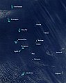 Satellite picture showing the atolls of the Lakshadweep except for Minicoy
 -
 Map
Map -
 Kiltan jetty
 -
Kiltan island seen from southern extreme point of reef also here is a small channel named Mooni
-
 An evening from Cocafulluckyar Kiltan Island


References
- ^ "Islandwise Area and Population - 2011 Census" (PDF). Government of Lakshadweep. Archived from the original (PDF) on 22 July 2016.
- ^ Registration Plate Numbers added to ISO Code
- ^ Mahatma Gandhi National Rural Employment Guarantee Act - Kiltan
- ^ Hydrographic Description (Indian Ocean Pilot)
- ^ R. H. Ellis, A short account of the Laccadive Islands and Minicoy, AES reprint 1992
External links
- Lagoon sizes
- Kiltan – Geographical information
- Kiltān – Oceandots at the Wayback Machine (archived 23 December 2010)
- List of Atolls Archived 13 August 2012 at the Wayback Machine
- An ornithological expedition to the Lakshadweep archipelago
- Sources towards a history of the Laccadive Islands
- FAO – An analysis of the carrying Capacity of Lakshadweep Coral Reefs