
Kings Park, New South Wales
| Kings Park Federal division(s) | Greenway | ||||||||||||||
|---|---|---|---|---|---|---|---|---|---|---|---|---|---|---|---|
| |||||||||||||||
Kings Park is a
Description
Kings Park is bounded by the
The suburb has three
History
Kings Park was originally part of Marayong, but with increased residential development, residents wanted a separate identity, and the developer's estate name was adopted in 1987.[2]
-
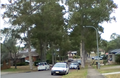 Street scene in Kings Park, New South Wales
 -
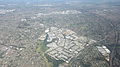 Kings Park area
 -
 Kings Park looking west with Westlink M7 reserve to the right behind trees


3.png)
Population
In the 2016 Census, there were 3,453 people in Kings Park. 69.9% of people were born in Australia. The next most common countries of birth were Philippines 3.0%, India 3.0% and England 2.9%. 75.3% of people spoke only English at home. The most common responses for religion were Catholic 32.4%, No Religion 21.3% and Anglican 15.2%.[1]
Economy
Kings Park is the current headquarters of Ichijo Homes, a company that builds energy-efficient houses.[3]
Transport
The suburb is served by Marayong railway station on the Richmond railway line and the Blacktown-Parklea branch of the North-West T-way.
References
- ^ a b Australian Bureau of Statistics (27 June 2017). "Kings Park (State Suburb)". 2016 Census QuickStats. Retrieved 15 March 2018.
- ^ "Kings Park". Geographical Names Register (GNR) of NSW. Geographical Names Board of New South Wales. Retrieved 4 August 2013.
- ^ Wellings, Susan (6 October 2012). "Power to the people". Domain. Retrieved 1 October 2023.
33°44′13″S 150°54′04″E / 33.737°S 150.901°E
This article related to the geography of Sydney is a stub. You can help Wikipedia by expanding it. |