
Kiryat Shmona Airport
Kiryat Shmona Airport שדה התעופה קריית שמונה | |||||||||||
|---|---|---|---|---|---|---|---|---|---|---|---|
AMSL 376 ft / 115 m | | ||||||||||
| Coordinates | 33°13′00.00″N 35°35′48.00″E / 33.2166667°N 35.5966667°E | ||||||||||
| Map | |||||||||||
 KSW  KSW | |||||||||||
| Runways | |||||||||||
| |||||||||||
Kiryat Shmona Airport (Hebrew: שדה התעופה קריית שמונה) (IATA: KSW, ICAO: LLKS) is a public Israeli airport located 2 km east of the northern town of Kiryat Shmona. The airport is operated by Kiryat Shmona Travellers Inc.
History
Its history was checkered based on lack of economic viability and local political differences.
Ben Ya'akov near Rosh Pina
, 30 km south.

-
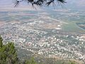 Kiryat Shemona and its airport in the background
 -
 Old (previous) terminal, permanently closed
 -
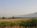 Runway 21 with Naftali hills in the background


References
- ^ "Tamir Company criticises the state: Mofaz and Siterman working illegally". Nfc.co.il (in Hebrew). 15 March 2007. Retrieved 5 April 2007.
- Ynetnews. 17 January 2006. Retrieved 17 January 2006.
- ^ "News collection: From the North to the South". Yedioth Ahronoth (in Hebrew). 12 March 2007. Archived from the original on 24 March 2007. Retrieved 5 April 2007.
- The Marker (in Hebrew). Retrieved 5 April 2007.[permanent dead link]
- ^ Zohar Blumenkrantz (17 May 2007). "Airline to stop flights to Galilee as of June 1 (2007)". Retrieved 2007-05-19.
| Airports | |||||||
|---|---|---|---|---|---|---|---|
| Border terminals |
| ||||||
| Defunct or former properties | |||||||
This article about an Asian airport is a stub. You can help Wikipedia by expanding it. |
This article about transport in Israel is a stub. You can help Wikipedia by expanding it. |