
Klokova
| Klokova (Κλόκοβα) | |
|---|---|
| Taphiassos | |
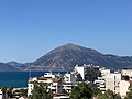
 View of Klokova from Rio in Achaea | |
| Highest point | |
| Peak | Klokova |
| Elevation | 1,039 m (3,409 ft)[1] |
| Coordinates | 38°21′43″N 21°40′57″E / 38.36194°N 21.68250°E |
| Geography | |
 Klokova (Κλόκοβα) | |
| Country | Greece |
| Regional unit | Aetolia-Acarnania |
Klokova (Greek: Κλόκοβα, also known as Paliovouna (Παλιοβούνα)) is a mountain in the southeast of Aetolia-Acarnania, in western Greece. In classical antiquity, the mountain was known as Taphiassus (Ταφιασσός).[2] Its highest point is 1,039 m.[1]
Geography
The mountain is located nearly 6 km west of Antirrio and sits on the northeast shore of the Gulf of Patras. A nearby mountain range is Arakynthos to the northwest, separated from Klokova by the river Evinos.
The National Road 5 runs along the southern foot of the mountain. This was once used for main traffic between Antirrio and Messolonghi as well as Ioannina, the traffic now carried by the Ionia Odos (part of the E55) running in the southern portion underneath with the Klokova Tunnel, which is 2.8 km long and was opened to traffic on 12 April 2017.[3]
Mythology
According to
Gallery
-
 Mount Klokova viewed from Patras, Greece.
 -
 A view of several mountains, including Klokova from Tsoukaleika.
 -
 A view of the Klokova Tunnel.


References
- ^ a b Oreivatein.com
- ^ a b
 Smith, William, ed. (1854). "Aetolia". Dictionary of Greek and Roman Geography. Vol. 1. London: John Murray. p. 63.
- ^ Ionia Odos: the section Klokova - Kefalovryso is opened on Holy Wednesday (in Greek)
External links
- Climbing Paliovouna (in Greek)