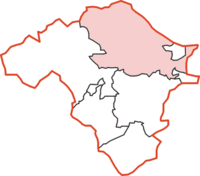
Knighton Rural District
Appearance
| Knighton | |
|---|---|
 | |
| Area | |
| • 1911 | 88,872 acres (359.65 km2) |
| • 1931 | 88,872 acres (359.65 km2) |
| • 1961 | 88,872 acres (359.65 km2) |
| Population | |
| • 1901 | 4,856 |
| • 1931 | 3,955 |
| • 1971 | 2,595 |
| History | |
| • Origin | Radnorshire |
| Status | Rural district |
| Government | Knighton Rural District Council |
| • HQ | Knighton |
| Subdivisions | |
| • Type | Civil parishes |
Knighton was, from 1894 to 1974, a
administrative county of Radnorshire, Wales
.
The district was formed by the
urban district
.
The rural district comprised seventeen civil parishes:[2]
- Beguildy
- Bleddfa
- Cascob
- Discoed
- Heyope
- Knighton
- Litton and Cascob
- Llananno
- Llanbadarn Fynydd
- Llanbister
- Llanddewi Ystradenny
- Llanfihangel Rhydrithon
- Llangunllo
- Norton
- Pilleth
- Stanage
- Whitton
The district was abolished in 1974 under the
District of Radnor in the new county of Powys
.
References
- ^ Census of England and Wales 1901, County Report, Radnorshire
- ^ "Relationships / unit history of Knighton". Vision of Britain. University of Portsmouth. Archived from the original on 2012-09-18. Retrieved 2009-02-10.
