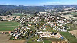
Kobersdorf
This article needs additional citations for verification. (March 2013) |
Kobersdorf | ||
|---|---|---|
 Southeast view of Kobersdorf | ||
|
Postal code 7332 | ||
| Area code | 02618 | |
| Vehicle registration | OP | |
| Website | [1] | |
Kobersdorf (
Geography
Kobersdorf is located in Middle Burgenland and is divided into the districts of Kobersdorf, Lindgraben, and Oberpetersdorf. The municipality lies at the foot of the
History
Like the rest of Burgenland, Kobersdorf belonged to the Kingdom of Hungary until 1920–21. After the end of the First World War, the western border area of Hungary was awarded to Austria by the Treaties of St. Germain and Trianon. Since 1921, the town has belonged to the newly founded State of Burgenland.
Kobersdorf was one of the Jewish Siebengemeinden of Burgenland. Its synagogue, built in 1860, is the only one in the seven communities that still stands. Since its restoration, it has been used for memorial services.
Kobersdorf has been a market town since 1973 (through a recently reissued VO 5).

Politics
Kobersdorf's mayor is
The mandate assignments in the Municipal Council (21 seats) are SPÖ 11, ÖVP 7,
Culture and landmarks
Business and Infrastructure
The most important employers are:
- the mineral water producer Waldquelle
- the Basalt Quarry on the Pauliberg
- the Hobby Versand Company
- the Reitter Bau Company
Notable residents
- Yosef Chaim Zonnenfeld
Sister cities
- Waldbrun in Baden-Württemberg, Germany
References
- ^ "Dauersiedlungsraum der Gemeinden Politischen Bezirke und Bundesländer - Gebietsstand 1.1.2018". Statistics Austria. Retrieved 10 March 2019.
- ^ "Einwohnerzahl 1.1.2018 nach Gemeinden mit Status, Gebietsstand 1.1.2018". Statistics Austria. Retrieved 9 March 2019.
- The information in this article is based on a translation of its German equivalent.
