
Kuiseb River
| Kuiseb River | |
|---|---|
Khomas Highland | |
| Mouth | Atlantic Ocean |
• location | Walvis Bay |
• coordinates | 23°07′S 14°32′E / 23.117°S 14.533°E |
• elevation | 0 m (0 ft) |
| Length | c. 480 km (300 mi) |
| Basin size | 15,500 km2 (6,000 sq mi) |
| Discharge | |
| • average | c. 20 million cubic metres per annum (710×106 cu ft/a) |
| Basin features | |
| Tributaries | |
| • left | Gomab River, Ojab River, Chausib River, Gaub River |
| • right | Koam River, Nausgomab River, Goagos River |
| Waterbodies | Friedenau Dam |
The Kuiseb River is an
The Kuiseb's catchment area (including its tributaries) is estimated to be between 15,500[3] and 16,692 km2 (6,445 sq mi).[4] It has a mean run-off of roughly 20 million cubic metres per annum (710×106 cu ft/a).[5] Friedenau Dam, built in 1972, is on the river.[6] In January 2005, for the first time in years, the Kuiseb flowed to the ocean.
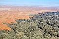
Between Naukluft and Namib the Kuiseb carved out a canyon in a barren and inaccessible area. During
In 1907, the area between the Swakop River and the Kuiseb was designated by the German colonial administration as a game reserve. The area is currently part of the Namib-Naukluft National Park. The Desert Research Foundation of Namibia (DRFN) is located at Gobabeb on the banks of the river.[9]
-
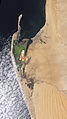 Natural-colour satellite image of the Kuiseb River.
 -
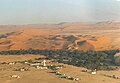
 Aerial view of Kuiseb River (2017)
 -
 Kuiseb River (2018)
 -
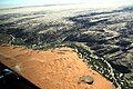
 Aerial view of the Gobabeb Training and Research Centre
 -
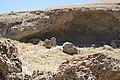 Ruins of the Shelter of Korn and Martin
 -
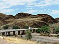 C14 bridge over the Kuiseb Canyon


.jpg)


See also
References
Notes
- ^ Malan 1998, p. 120–125.
- ^ Moritz 1997, pp. 4–5.
- ^ ISBN 9991670947.
- OCLC 940637734.
- ^ "ELECTIONS 2010: Erongo regional profile". New Era. 16 November 2010. Archived from the original on 6 September 2012.
- ^ Friedenau Archived 2008-11-21 at the Wayback Machine at NamWater
- ISBN 9783935453035.
- ISSN 0022-1694.
- ^ "Desert Research Foundation of Namibia". namibweb.com. Retrieved 3 October 2019.
Literature
- Malan, Johan S (1998). Die Völker Namibias [The Tribes of Namibia] (in German). Windhoek, Göttingen: Klaus Hess.
- Moritz, Walter (1997). Verwehte Spuren in der Namibwüste - Alte Ansiedlungen am Kuiseb [Withered Traces in the Namib - Old Settlements on the river Kuiseb] (in German). Windhoek: Typoprint. ISBN 99916-750-0-0.
- The original entry was from the NASA Earth Observatory [1]
Videos
- 'HURININ People of the Sea' - The Topnaar people’s search for human rights and recognition on YouTube