
Namib-Naukluft National Park
| Namib-Naukluft Park, Namibia | |
|---|---|
.jpg) Sand dunes near Sossusvlei | |
 | |
| Location | Namibia |
| Nearest city | Windhoek |
| Coordinates | 24°32′47″S 15°19′47″E / 24.54639°S 15.32972°E |
| Area | 49,768 km2 (19,216 sq mi) |
| Established | 1907 |
| Governing body | Ministry of Environment and Tourism |
The Namib-Naukluft Park is a
Location and description
With an overall area of 49,768 km2 (19,216 sq mi), the Namib-Naukluft National Park was at the time of its last expansion the largest game park in Africa and the fourth largest in the world.[1] It consists of a strip of land on the Atlantic Ocean, including 1,609 kilometres (1,000 mi) of sea, that extends roughly 600 kilometres (370 mi) north-to-south from the Swakop River to the B4 road to Lüderitz.[2]
Wildlife

A surprising collection of creatures survives in the hyper-arid region, including snakes, geckos, unusual insects, hyenas, gemsboks, springboks, leopards, African wildcats, cape foxes, baboons, caracals, bat-eared foxes and jackals.
Geography
The region is characterised by high, isolated
More moisture comes in as a fog off the Atlantic Ocean then falls as rain, with the average of 106 millimeters of rainfall per year concentrated in February and April.
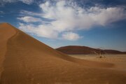
The winds that bring in the fog are also responsible for creating the park's towering
These dunes are the tallest in the world, in places rising more than 300 meters (almost 1000 feet) above the desert floor. The dunes taper off near the coast, and lagoons, wetlands, and mudflats located along the shore attract hundreds of thousands of birds.
'Namib' means "open space", and the Namib Desert gave its name to form Namibia – "land of open spaces".
History
The park was established in 1907 when the German Colonial Administration proclaimed three game reserves in
In 1966 "Game Reserve No. 3" was deproclaimed, and the Namib Desert Park was established in its stead. The Namib Desert Park included a small area north of the Swakop River where
The park's present boundaries were established in 1986 when the government was given control over parts of the
Gallery
-
 Satellite photo indicating the borders of the Namib-Naukluft National Park and the Namib Rand Nature Reserve
 -
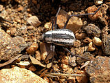 Namib desert beetle, Stenocara gracilipes
 -
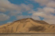
 High dunes in the Namib desert
 -
 550-year-old dead trees inDead Vlei
 -
 A typical dune in the park
 -
 Moon landscape near Swakopmund
 -
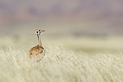 Rüppell's korhaan in the grasslands near the dunes
 -
 Isolated quiver tree at Namib-Naukluft Park
 -
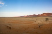
 Dunes in the Namib-Naukluft National Park
 -
 Road to Dead Vlei in the Namib-Naukluft National Park
 -
 Namib-Naukluft National Park
 -
 Trees in the Namib-Naukluft National Park
 -
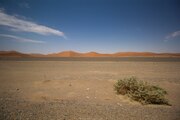
 Namib-Naukluft National Park
 -
 Road in the Namib Desert in the Namib-Naukluft National Park


.jpg)


See also
References
- ^ Namib Naukluft Park
- ^ "Namib-Naukluft National Park | Namibia". Wild Safari Guide. Retrieved 2021-02-04.
- ^ a b c Bridgeford, Peter (2008). "One Hundred Years of Conservation. From Game Reserve No.3 to Namib-Naukluft Park" (PDF). Journal. 56 (56). Namibia Scientific Society: 45–62.
External links
- "Namib-Naukluft National Park, Namibia (1)". NASA Earth Observatory. Archived from the original on 2003-10-21.
- "Namib-Naukluft National Park, Namibia (2)". NASA Earth Observatory. Archived from the original on 2006-10-11.
- Ministry of Environment and Tourism report
- Gobabeb Training & Research Centre - A major centre for Namib ecological and development research since 1962; joint venture between the Ministry of Environment and Tourism Archived 2010-07-15 at the Wayback Machine and the Desert Research Foundation of Namibia
- Visiting Namib-Naukluft National Park, Namibia