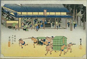
Kusatsu-juku
Kusatsu-juku 草津宿 | |||||
|---|---|---|---|---|---|
| post station | |||||
 Hiroshige's print of Kusatsu-juku, in the Sixty-nine Stations of the Kiso Kaidō series | |||||
| General information | |||||
| Location | Kusatsu, Shiga (former Ōmi Province) Japan | ||||
| Coordinates | 35°01′03.6″N 135°57′37.7″E / 35.017667°N 135.960472°E | ||||
| Elevation | 127 meters | ||||
| Line(s) | Tōkaidō Nakasendō | ||||
| Distance | 457.5 km from Edo | ||||
| |||||
| |||||


Kusatsu-juku (草津宿, Kusatsu-juku) was the fifty-second of the fifty-three stations of the Tōkaidō as well as the sixty-eighth of the sixty-nine stations of the Nakasendō. It is located in the downtown area of the present-day city of Kusatsu, Shiga Prefecture, Japan.
History
Kusatsu has been a transportation hub for east–west travel on the ancient
Coming from Moriyama-juku, the borders of Kusatsu-juku started at the banks of the Kusatsu River and extended to the present-day Miya-chō in Kusatsu.Per the 1843 "東海道宿村大概帳" (Tōkaidō Shukuson Taigaichō) guidebook issued by the Inspector of Highways (道中奉行, Dōchu-būgyō), the town had a population of 2351 in 586 houses, including two honjin, two waki-honjin, and 72 hatago.[1]
Of the two honjin, one was constructed in 1635 and stood until 1870.[2] That honjin was later repaired and opened as a museum in 1996.[2]
Kusatsu-juku Honjin
Kusatsu-juku had two honjin, both of which were owned by the Tanaka family. The head of the family always had the name of "Tanaka Shichizaemon". One of the honjin was named the "Tanaka Shichizaemon Honjin" and since the family was also in the lumber business, the second was named the "Kiya Honjin" Only the "Tanaka Shichizaemon Honjin" survives and was designated as a National Historic Site in 1949.[3] It covers a 4719 square meter site, with a floor area of 1547 square meters. It is adjacent to the Kusatsu River on one side, and protected by moats and high walls on the other sides.[1]
The first honjin was built by the Tanaka Shichizaemon family in 1635. In June 1699, the two main players of the
Kusatsu-juku in The Sixty-nine Stations of the Kiso Kaidō
Kusatsu-juku in The Fifty-three Stations of the Tōkaidō
Neighboring post towns
- Nakasendō
- Moriyama-juku - Kusatsu-juku - Ōtsu-juku
- Tōkaidō
- Ishibe-juku - Kusatsu-juku - Ōtsu-juku
Notes
- ^ ISBN 4311750404.(in Japanese)
- ^ a b Kusatsu-shi, Kusatsu-juku. City of Kusatsu. Accessed July 17, 2007.
- ^ "草津宿本陣" [Kusatsu-juku honjin] (in Japanese). Agency for Cultural Affairs. Retrieved August 20, 2020.
References
- Berna, Cristina (2020). Hokusai 53 Stations of the Tōkaidō 1805-1806. Missys Clan. ISBN 1649454767.
- Yagi, Makio (2019). 新版 ちゃんと歩ける東海道五十三次 西 見付宿~京三条大橋 +佐屋街道. 山と渓谷社. ISBN 4635600874.(in Japanese)
- Sasaki, Moritoshi (2010). 歌川広重保永堂版 東海道五拾三次 (謎解き浮世絵叢書). Nigensha. ISBN 4544212014.(in Japanese)
- Izzard, Sebastian (2008). The Sixty-Nine Stations of the Kisokaido. George Braziller. ISBN 0807615935.
- Berna, Cristina (2019). Hiroshige 69 Stations of the Nakasendō. Missys Clan. ISBN 2919787667.
- Kishimoto, Yutaka (2016). 中山道浪漫の旅 書き込み手帖. Shinano Mainichi Shimbun. ISBN 4784072977.(in Japanese)
- Yagi, Makio (2014). ちゃんと歩ける中山道六十九次 西 藪原宿~京三条大橋. 山と渓谷社. ISBN 4635600785.(in Japanese)


