
Kuusalu Parish
Kuusalu Parish
Kuusalu vald | |
|---|---|
 Flag  Coat of arms | |
 Kuusalu Parish within Harju County. | |
| Country | |
| County | |
| Administrative centre | Kiiu |
| Government | |
| • Mayor | Terje Kraanvelt |
| Area | |
| • Total | 707.97 km2 (273.35 sq mi) |
| Population (01.04.2019) | |
| • Total | 6,464 |
| • Density | 9.1/km2 (24/sq mi) |
| ISO 3166 code | EE-353 |
| Website | www.kuusalu.ee |
Kuusalu Parish (Estonian: Kuusalu vald) is a rural municipality in northern Estonia, the largest in Harju County. After joining with the adjacent Loksa Parish in 2005, the municipality has now a population of 6,863 (as of 1 January 2009)[1] and covers an area of 707.97 km2 (273.35 sq mi).[2] The population density is 9.7 inhabitants per km2.
A significant share of the municipality's territory (between 40% and 60%
The administrative centre of the municipality is Kiiu. There is a total of 3 small boroughs — Kuusalu (1225 inhabitants), Kiiu (893 inhabitants) and Kolga (501 inhabitants) — and 64 villages in Kuusalu Parish: Allika, Andineeme, Aru, Haavakannu, Hara, Hirvli, Ilmastalu, Joaveski, Juminda, Kaberla, Kahala, Kalme, Kasispea, Kemba, Kiiu-Aabla, Kodasoo, Koitjärve, Kolga-Aabla, Kolgaküla, Kolgu, Kõnnu, Kosu, Kotka, Külmaallika, Kupu, Kursi, Kuusalu, Leesi, Liiapeksi, Loksa, Mäepea, Murksi, Mustametsa, Muuksi, Nõmmeveski, Pala, Pärispea, Parksi, Pedaspea, Põhja, Pudisoo, Rehatse, Rummu, Salmistu, Saunja, Sigula, Sõitme, Soorinna, Suru, Suurpea, Tammispea, Tammistu, Tapurla, Tõreska, Tsitre, Turbuneeme, Uuri, Vahastu, Valgejõe, Valkla, Vanaküla, Vihasoo, Viinistu, Virve.
The current mayor (vallavanem) is Terje Kraanvelt.[4]
Religion
Religion in Kuusalu Parish (2021) [1]
Gallery
-
 Kiiu Manor
 -
 Kuusalu church
 -
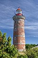 Mohni lighthouse
 -
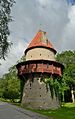 Kiiu tower
 -
 Kolga manor
 -
 Viru Bog in winter
 -
 Coast atPärispea Peninsula
 -
 Suru Suursoo in early morning
 -
 Nõmmeveski waterfall
 -
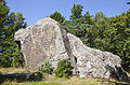 Jaani-Tooma boulder


See also
References
- ^ "Rahvastik" (in Estonian). Kuusalu vald. Archived from the original on 7 July 2010. Retrieved 13 December 2009.
- ^ "Kirjeldus" (in Estonian). Kuusalu vald. Archived from the original on 18 December 2009. Retrieved 13 December 2009.
- ISBN 978-9985-881-56-9. Archived from the original(PDF) on 2011-07-19. Retrieved 2009-02-10.
- ^ "Ametnikud - Kuusalu vallavalitsus".
External links
- Official website (available only in Estonian)
59°26′38″N 25°26′29″E / 59.44389°N 25.44139°E
| Urban municipalities | ||
|---|---|---|
| Rural municipalities | ||
| International | |
|---|---|
| National | |
This Harju County location article is a stub. You can help Wikipedia by expanding it. |