
Lažai
Lažai | |
|---|---|
Village | |
UTC+3 (EEST ) |
Lažai ('
Sosiai forest
. There is a former school.
Demography
|
| ||||||||||||||||||||||||||||||
| Source: 1902, 1923, 1959 & 1970, 1979, 1989, 2001, 2011 | |||||||||||||||||||||||||||||||
Images
-
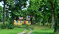
 A homestead by the road to Užupė
 -
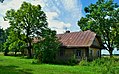 An old Aukštaitian gryčia in Lažai
 -
 A former school


References
- ^ "Łoże". Geographical Dictionary of the Kingdom of Poland (in Polish). 15 pt. 2. Warszawa: Kasa im. Józefa Mianowskiego. 1902. p. 277.
- ^ "2011 census". Statistikos Departamentas (Lithuania). Retrieved August 21, 2017.
