
La Paz, State of Mexico
La Paz | |
|---|---|
Municipality | |
|
UTC-5 (Central) | |
| Postal code (of seat) | 56400 |
| Website | (in Spanish) www.losreyeslapaz.gob.mx |
La Paz is a
History
This area was the land of the
The municipality was founded in 1875 by President Sebastián Lerdo de Tejada, furthering a process of consolidation of the area that had begun in the prior century. The towns of La Magdalena Atlicpac, San Sebastián Chimalpa and Tecamachalco were unified under the control of La Magdalena Atlicpac. Only later would Los Reyes become the seat.[1]
Demographics
The municipality covers a total surface area of 26.71 square kilometers (10.31 sq mi) and, in the year 2010 census, reported a population of 253,845.
The municipality consists of 18 localities (15 urban and 3 rural), of which its municipal seat, Los Reyes Acaquilpan, also known as Los Reyes La Paz, which had a 2010 census population of 85,359 inhabitants, is the largest. Line A of the
Towns and villages
Localities (cities, towns, and villages) are:[2]
| Name | 2010 Census Population |
|---|---|
| Los Reyes Acaquilpan | 85,359 |
| San Isidro | 33,737 |
| La Magdalena Atlicpac | 26,429 |
| Emiliano Zapata | 25,309 |
| San Sebastián Chimalpa | 12,951 |
| Lomas de San Sebastián | 12,372 |
| Professor Carlos Hank González | 10,416 |
| El Pino | 8,332 |
| San José las Palmas | 8,203 |
| Tecamachalco | 6,780 |
| Arenal | 6,700 |
| Lomas de Altavista | 5,704 |
| Unidad Acaquilpan | 4,806 |
| Bosques de la Magdalena | 2,803 |
| Techachaltitla | 1,994 |
| Lomas de San Sebastián | 1,447 |
| Colonia Máximo de la Cruz | 429 |
| Los Pirules | 74 |
| Total Municipality | 253,845 |
Gallery
-
 The "municipal palace" or main government building for the city and municipality. It is decorated for the upcoming Independence Day celebrated on Sept 16
 -
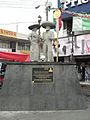 Statue dedicated to charros in the plaza in front of the municipal palace. Part of the inscription reads "For more than a century, our men and women have celebrated the "Carnaval de Charros" with their characteristic masks and outfit year after year and it is our pride to continue preserving this noble tradition"
 -
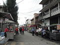 Street vendors on Hombres Ilustres street near the municipal palace
 -
 View of (extinct) volcano "La Caldera" taken from theMetro La Paz station of the Mexico City Metroin the city/municipality of Los Reyes Acaquilpan
 -
 Entrance to Mexico City Metro stationLos Reyes
 -
 line of bicycle taxis waiting for business on Horacio Zuñiga Street just outside the Metro Los Reyes station


References
- ^ a b c d "Enciclopedia de los Municipios de Mexico Estado de Mexico Los Reyes La Paz". Archived from the original on 2007-09-27. Retrieved 2008-03-09.
- ^ a b 2010 census tables: INEGI Archived 2013-05-02 at the Wayback Machine
- Link to tables of population data from Census of 2005 INEGI: Instituto Nacional de Estadística, Geografía e Informática
External links
- Los Reyes La Paz (Enciclopedia de los municipios de México)
- Official Site, Los Reyes La Paz
19°21′38″N 98°58′48″W / 19.36056°N 98.98000°W

| International | |
|---|---|
| National | |