
Ladestien

Ladestien (English: the Lade Trail) is a broad walking track that strolls along the
Charlottenlund
. The western part climbs small hilltops, often with a beautiful view of the Trondheimsfjord. The eastern part is almost flat.
There is lush vegetation along the track, with
municipality and used for representational purposes.There are several beaches (mainly rocky or with pebbles) along Ladestien, some of the most popular are Ringvebukta (not far from Ringve Museum and botanical garden) and Djupvika; the latter includes a large lawn and volleyball net. Swimming in the fjord is indeed refreshing, although a water temperature of 18 °C (64 °F) is fairly common during warm spells, and in warm summers water temperatures might reach 21 °C (70 °F). In nice summer weather, a walk along the lush Ladestien with the calm waves from the fjord rolling gently against rocks and beaches might give associations to places much further south.[1]
Media gallery
-
 Djupvika
 -
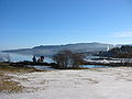 Eastern part of Ladestien in winter, Feb 23 2003
 -
 View from hilltop
 -
 Korsvika, western part of Ladestien
 -
 Korsvika, view from hill


References
- ^ "Ladestien" (in Norwegian). Trondheim kommune. Archived from the original on 2011-07-18. Retrieved 2011-03-24.
Wikimedia Commons has media related to Ladestien (Trondheim).