
Lincoln Township, Russell County, Kansas
Lincoln Township | ||
|---|---|---|
ZIP code 67665 | ||
| Area code | 785 | |
| GNIS feature ID | 475311[2] | |
Lincoln Township is a
History
Lincoln Township was organized from part of Russell Township in the 1880s.[3] Grant Township was organized from part of Lincoln Township in 1907.[4]
Geography
The center of Lincoln Township is located at 38°44′26″N 98°52′11″W / 38.74056°N 98.86972°W (38.7405671, −98.8698075) at an elevation of 1,890 feet (580 m).[2] The township lies in the Smoky Hills region of the Great Plains.[5] The Smoky Hill River runs in and out of the township, winding back and forth across its northern border. Landon Creek, a tributary of the river, flows northeast through the township.[6]
According to the United States Census Bureau, Lincoln Township comprises an area of 36.13 square miles (93.6 km2), all of it land.[7] Located in southwestern Russell County, it contains no incorporated settlements. One unincorporated community, Milberger, is located in the southwestern part of the township.[6] Lincoln Township borders Grant Township to the north, Fairfield Township to the east, Barton County's Wheatland and Fairview Townships to the south, Winterset Township to the west, and Big Creek Township to the northwest.[7]
Demographics
| Census | Pop. | Note | %± |
|---|---|---|---|
| 1890 | 709 | — | |
| 1900 | 1,088 | 53.5% | |
| 1910 | 431 | −60.4% | |
| 1920 | 488 | 13.2% | |
| 1930 | 440 | −9.8% | |
| 1940 | 467 | 6.1% | |
| 1950 | 350 | −25.1% | |
| 1960 | 288 | −17.7% | |
| 1970 | 205 | −28.8% | |
| 1980 | 146 | −28.8% | |
| 1990 | 136 | −6.8% | |
| 2000 | 147 | 8.1% | |
| 2010 | 150 | 2.0% | |
| U.S. Decennial Census | |||
As of the
There were 60 households, out of which 33.3% had children under the age of 18 living with them, 65.0% were married couples living together, 8.3% had a female householder with no husband present, and 26.7% were non-families. 25.0% of all households were made up of individuals, and 15.0% had someone living alone who was 65 years of age or older. The average household size was 2.50, and the average family size was 2.98.[1]
In the township, the population was spread out, with 26.7% under the age of 18, 5.9% from 18 to 24, 21.3% from 25 to 44, 24.8% from 45 to 64, and 21.3% who were 65 years of age or older. The median age was 43 years. For every 100 females, there were 89.9 males. For every 100 females age 18 and over, there were 100.0 males.[1]
Education
Lincoln Township lies within unified school district 407, Russell County Schools.[8][9]
Transportation
References
- ^ a b c d e "U.S. Census website". United States Census Bureau. Retrieved July 4, 2011.
- ^ a b "US Board on Geographic Names". United States Geological Survey. October 25, 2007. Retrieved January 31, 2008.
- United States Government Printing Office, p. 154, retrieved July 4, 2011
- United States Government Printing Office, p. 661, retrieved July 4, 2011
- ^ "2003–2004 Official Transportation Map" (PDF). Kansas Department of Transportation. 2003. Retrieved July 4, 2011.
- ^ a b "General Highway Map – Russell County, Kansas (township map)" (PDF). Kansas Department of Transportation. 1975. Retrieved July 4, 2011.
- ^ a b "Kansas: 2000 – Population and Housing Counts" (PDF). United States Census Bureau. July 2003. Retrieved July 4, 2011.
- ^ "Kansas Unified School Districts (map)" (PDF). Kansas State Department of Education. Archived from the original (PDF) on July 21, 2011. Retrieved July 4, 2011.
- ^ "USD 407 Russell County Schools". USD 407. Retrieved July 4, 2010.
- ^ "General Highway Map – Russell County, Kansas" (PDF). Kansas Department of Transportation. October 1, 2010. Retrieved July 4, 2011.
- ^ "Maps". Bing Maps. Retrieved July 4, 2011.
Municipalities and communities of Russell County, Kansas, United States | ||
|---|---|---|
| Cities | 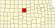 | |
| Unincorporated communities | ||
| Ghost towns | ||
| Townships | ||
| Footnotes | ‡This community also has portions in an adjacent county or counties. | |
| ||