
List of municipalities in Rio Grande do Norte

22nd largest by area, out of 26 states.[2][3][4][5] It is home to cities such as Natal, Mossoró, and São Gonçalo do Amarante
.
The land that became Rio Grande do Norte was a
Brazil wood in the area, had a foothold on the land until the Portuguese expelled them in 1598.[6] The Dutch took the land in 1634 as a part of Dutch Brazil and reigned until 1654, when they were defeated by the Portuguese.[8] In 1701, Rio Grande do Norte joined the Captaincy of Pernambuco, and became a province in 1822 and a state of Brazil in 1889.[6]
Rio Grande do Norte is divided into 167
Senator and Rio Grande do Norte Governor José Georgino Avelino,[9]
which covers an area of 26 square kilometres (10 sq mi).
Municipalities
-
-
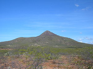 Pico do Cabugi, an extinct volcano in Angicos
 -
 The Piranhas River in Macau
 -
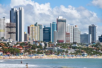 Natal, the capital of Rio Grande do Norte
 -
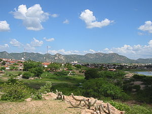
 Parelhas celebrating the 150th anniversary of its founding
 -


See also
- Geography of Brazil
- List of cities in Brazil
References
- ^ Smith, Benjamin Eli (1918). The Century cyclopedia of names: a pronouncing and etymological dictionary of names in geography, biography, mythology, history, ethnology, art, archaeology, fiction, etc., etc. Vol. 6. The Century Company. p. 857.
- ^ "Censo 2010: população do Brasil é de 190.732.694 pessoas" [Census 2010: Brazil's population is 190,732,694 people] (in Portuguese). Brazilian Institute of Geography and Statistics. Archived from the original on 18 January 2012. Retrieved 26 November 2011.
- ^ "Área Territorial Oficial" [Official Territorial Area] (in Portuguese). Brazilian Institute of Geography and Statistics. Archived from the original on 27 June 2012. Retrieved 26 November 2011.
- ^ a b "Censo 2010– Rio Grande do Norte" [Census 2010– Rio Grande do Norte] (PDF) (in Portuguese). Brazilian Institute of Geography and Statistics. 29 November 2010. Archived from the original (PDF) on 14 June 2011. Retrieved 26 November 2011.
- ^ Zip file) (in Portuguese). Brazilian Institute of Geography and Statistics. 1 July 2008. Retrieved 26 November 2011.
- ^ a b c "História" [History] (in Portuguese). State Government of Rio Grande do Norte. Archived from the original on 22 March 2012. Retrieved 10 March 2012.
- ISBN 978-0-313-26257-9.
- ^ "Paraíba & Rio Grande do Norte" (PDF). Lonely Planet. Archived from the original (PDF) on 2 October 2012. Retrieved 10 March 2012.
- ^ "Senador Georgino Avelino" (in Portuguese). Portal Oficial De Turismo do Rio Grande do Norte. Archived from the original on 2 April 2015. Retrieved 6 March 2015.
- ^ "São Miguel do Gostoso entra na onda do kitesurf" [São Miguel do Gostoso enters the wave of the kite]. Paraná Online (in Portuguese). 23 August 2008. Archived from the original on 4 March 2016. Retrieved 16 March 2012.
- Empresa Brasileira de Pesquisa Agropecuária. Archived from the originalon 28 March 2013. Retrieved 18 February 2012.
- ^ Zip file) (in Portuguese). Brazilian Institute of Geography and Statistics. Retrieved 22 April 2020. DTB_BRASIL_MUNICIPIO.xls within zip file.
Capital: Natal | |||||||||||||||
| Mesoregion Agreste Potiguar |
|  | |||||||||||||
| Mesoregion Central Potiguar |
| ||||||||||||||
| Mesoregion Leste Potiguar |
| ||||||||||||||
| Mesoregion Oeste Potiguar |
| ||||||||||||||