
Little St Bernard Pass
| Little St. Bernard Pass | ||
|---|---|---|
Elevation 2,188 m (7,178 ft) | | |
| Traversed by | N 90/SS26 | |
| Location | Rhône-Alpes, France Aosta Valley, Italy | |
| Range | Alps | |
| Coordinates | 45°40′49″N 06°53′02″E / 45.68028°N 6.88389°E | |
 Little St Bernard Pass Location of Little St Bernard Pass | ||

The Little St Bernard Pass (French: Col du Petit Saint-Bernard, Italian: Colle del Piccolo San Bernardo) is a
The road across this pass (D1090 from
At the summit, the road cuts through a
In the Roman era, a temple dedicated to Jupiter was erected nearby along with a mansio serving travellers along the pass, and it is thought that Carthaginian general Hannibal used this route.[2][3][4]
Tour de France
The Little St Bernard Pass was first crossed by the Tour de France in 1949 and has been featured three times since. In 2007, Montée d'Hauteville was climbed on stage 8 of the Tour de France. The pass was featured in the 2009 Tour de France Stage 16 on 21 July from Martigny (Switzerland) to Bourg-Saint-Maurice, 160 km, which also features the Great St Bernard Pass.[5]
| Year | Stage | Category | Leader at the summit |
|---|---|---|---|
| 2009 | 16 | 1 | Franco Pellizotti |
| 1963 | 17 | 2 | Federico Bahamontes |
| 1959 | 18 | 1 | Michele Gismondi |
| 1949 | 17 | 2 | Gino Bartali |
Route
From Bourg-Saint-Maurice to the south-west, the Col du Petit Saint-Bernard is 26.5 km long. Over this distance, the climb is 1,348 m (4,423 ft) (an average slope of 5.1%), with the steepest sections at 8.1% at the start of the climb. The first 15.5 km (9.6 mi) to La Rosière forms the Montée d'Hauteville climb.
From Pré-Saint-Didier (in the Aosta Valley region of north-western Italy), the pass is 23.5 km (14.6 mi) long. Over this distance the climb is 1,184 m (3,885 ft) (an average slope of 5%).
Gallery
-
 Little St Bernard Hospice
 -
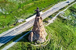 Statue of Saint Bernard of Menthon near the pass
 -
 Lac Sans Fond on the French side above the hill
 -
 Verney Lake on the Italian side, near the road


See also
Notes
- ^ "Etat des principaux cols routiers francais (ouverture, déneigement)". Sport Passion – Conseils et entraînement du sportif (in French). Retrieved 2018-08-27.
- JSTOR 297963.
- ^ Ball, Philip (April 3, 2016). "The Truth about Hannibal's Route across the Alps". The Guardian. Retrieved April 15, 2016.
- ^ Harrsch, Mary (April 13, 2016). "Hannibal's Route over the Alps or just Horse S***?". Roman Times. Retrieved April 13, 2016.
- ^ "Grande Chenalette". 12 July 2009. Archived from the original on 2009-07-05. Retrieved 2009-07-12.
External links
- Profile of Little St. Bernard Pass on climbbybike.com
- Little St. Bernard Pass in Tour de France (in French)
- Photos of Little St. Bernard Pass
- Coolidge, William Augustus Brevoort; Ashby, Thomas (1911). . Encyclopædia Britannica. Vol. 23 (11th ed.). pp. 1017–1018.
| International | |
|---|---|
| National | |
| Other | |