
Machars
This article has multiple issues. Please help improve it or discuss these issues on the talk page. (Learn how and when to remove these template messages)
|
The Machars
Machair Ghallghaidhealaibh ( Scottish Gaelic ) | |
|---|---|
| Highest elevation | 197m (Mochrum Fell) |
The Machars (
are frequently seen in the seas.Geography
The Machars peninsula is roughly defined by a northern boundary stretching from
Past the southern tip of the peninsula, the shoreline leaves Wigtown Bay and becomes part of
Generally speaking the Eastern half of the Machars can be described as being a landscape of rolling green hills and scattered woodland which forms a perfect setting for the large scale dairy industry which can be found here. In fact up until recent decades a large scale creamery was to be found at
The other principal settlements on the peninsula are: Kirkcowan, Whithorn, Isle of Whithorn, Kirkinner, Sorbie, Mochrum, Elrig, Bladnoch and Whauphill.
There are a number of large lochs in the area including Mochrum Loch, Castle Loch and the White Loch of Myrton.
History
The area is rich in prehistoric remains, mainly in the form of
Burrow Head (the southernmost tip of the peninsula) is about 18 miles (29 kilometres) from Point of Ayre on the Isle of Man, and trade links have long existed between the two places, much of which involved smuggling.
The primary industry in the area was agriculture, though today the tourist industry probably employs more people and generates more income.
Saint Ninian
RAF Wigtown
The Machars is also home to the former RAF Wigtown. The airfield, which was opened in 1941 and is often referred to as Baldoon, was used in World War II as a training school - hosting the No 1 Air Observers School from September 13, 1941, to February 1, 1942, and operating in conjunction with a tracked target range near the coast to the southeast. Although the site originally consisted of grass runways, flooding of the land soon caused these to become unusable, and two concrete runways were installed during 1942. Operations at the airfield ceased in 1945, to coincide with the end of the war, and control of the site was given over to Maintenance Command which was placed in care and maintenance, transferring to No 14 Maintenance Unit from July 1, 1946, to March 1, 1948, when the airfield was finally closed.[2]
Despite considerable deterioration much of the airfield remains intact; with the original control tower still standing and nearly all the perimeter and access roads remaining. Furthermore, the concrete bases of many of the hangars and other buildings can still be seen on the ground. Today much of the land has reverted to agricultural use, with the site becoming popular for locals to conduct leisure activities – such as walking or cycling.
Gallery
-
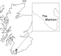 The location of The Machars in Scotland.
 -
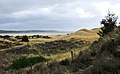
 A Machars beach at Wigtown.
 -
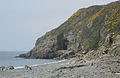
 Machars Coastline looking south from Cruggleton Castle.
 -
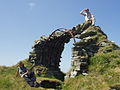 The remains of Cruggleton Castle.
 -
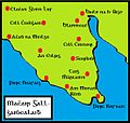 Map of the Machars with Scottish Gaelic placenames.
 -
 The Machars, as viewed from Torrs Warren with Luce Bay standing between.
 -
 St Ninian's Cave, Physgill


References
- ^ "SND: machair". Dictionaries of the Scots Language. Retrieved 16 February 2022.
- ^ "Secret Scotland - RAF Wigtown". www.secretscotland.org.uk.