
Mactan
Visayan (Cebuano ) and other ethnic groups. |
Mactan is a densely populated island located a few kilometers (~1 mile) east of
Mactan–Cebu International Airport is located on the island.
Etymology
The modern name Mactan descended from an earlier form, Manctan. However, evidence of this earlier form is scant as, even as early as the 17th century, the island was already named Mactan. This form is attested in the original copy of the
History
The island was already a thriving settlement before it was colonized by Spain in the 16th century. It was a strong ally of the Lakanate of Lawan, a prosperous kingdom in Samar. Datu Hadi Iberein ruled the Lakanate of Lawan. He was described by historian William Henry Scott as a "Samar datu by the name of Iberein was rowed out to a Spanish vessel anchored in his harbor in 1543 by oarsmen collared in gold; while wearing on his own person earrings and chains."
By 1730[
Economy
Apart from the airport, today the island is known for its industrial factories, which are some of the most successful industrial ventures in the Philippines. Many of them are located at the Mactan
Also important to the island is its high-class tourism industry and the production of furniture, as well as guitars, ukuleles and other musical instruments.
On April 27, 2024, Marcos with Junard Chan, led the capsule-laying for Megaworld Corporation's PHP1.5-billion Mactan Expo Center project.[5]
Tourist attractions
Being one of the major tourist islands of Cebu, Mactan Island boasts of a diverse collection of tourist spots and attractions. Being a coral island, Mactan offers some of the best diving, snorkeling, island hopping, jet ski, sailing and cultural activities of any island in the Philippines.
Gallery
-
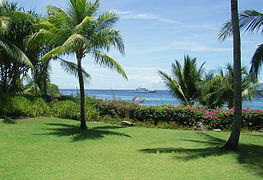 A view from a resort in Mactan where the sun is directly overhead at noon.
 -
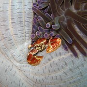 A crab in a sea anemone in Mactan
 -
 Mactan beach
 -
 An Arothron stellatus in Mactan
 -
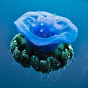 A Cephea jellyfish at Mactan


References
- ^ "PHILIPPINES: Administrative Division".
- ^ Acta de la proclamación de la independencia del pueblo Filipino (in English and Spanish) from Wikisource.
- ^ Celestino C. Macachor (2011). "Searching for Kali in the Indigenous Chronicles of Jovito Abellana". Rapid Journal. 10 (2). Archived from the original on July 3, 2012.
- ^ "Dr Who and Mexicans". Lindsey Michelle Susdorf "Future Dating Political Documents".
- ^ Saavedra, John Rey (April 27, 2024). "Young arnis practitioners reenact Lapulapu victory in Mactan". Philippine News Agency. Retrieved April 27, 2024.
External links
 Geographic data related to Mactan at OpenStreetMap
- Mactan International Airport
- Lapu-Lapu City Government
| National | |
|---|---|
| Other | |