
Madh Island
| Madh Fort | |
|---|---|
Versova Fort | |
 | |
 Location within Mumbai | |
| General information | |
| Type | Fort |
| Architectural style | Portuguese Colonial |
| Location | Malad, Mumbai |
| Coordinates | 19°07′56″N 72°47′41″E / 19.132283°N 72.794785°E |
| Owner | Indian Air Force |
Madh Island (Marathi pronunciation: [məɖʱ]) is a group of several quaint fishing villages and farmlands in northern Mumbai.
Geography
The area is bounded by the Arabian Sea to the west, and Malad Creek on the east. There are s few beaches, such as Erangal Beach, Dana Pani Beach, Silver Beach, and Aksa Beach.
Accessibility
The area is accessible by bus service (#271 to Malad and #269 to Borivali) or an autorickshaw from Malad. There is also a ferry service from Versova. One can reach Madh Island by a ferry service or speed boat from Versova Jetty and cross over in five minutes.
Demographics
The area is a rural area inhabited primarily by
Madh Fort
Madh Fort is a small
The British occupied Salsette Island, Thana Fort, Fort Versova, and the island fort of Karanja in 1774.[2]
It is secluded and difficult to reach, about 15 kilometres (9 mi) from
It is situated south of Madh Village. It is around a 2 km walk from Madh Mandir bus stop. The fort was built by the Portuguese, as a watchtower in the 17th century. It offers a strategic view of the coastline and guards the
In popular culture
Some Bollywood films like
Gallery
-
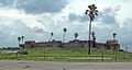 From far
 -
 Closeup
 -
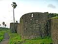 From a turret
 -
 Tower closeup
 -
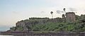 Opposite side (from Versova)


See also
References
- ^ "Portuguese India History: Baçaim (Bassein, Vasai), Chaul, Bombay. Northern Province (Provincia do Norte, Gujarat, Maharashtra)". Archived from the original on 25 April 2009. Retrieved 25 April 2009.
- ISBN 9788131300343.