
Mairan (crater)
Jean J. d'Ortous de Mairan |

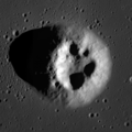
Mairan is a
The outer rim of Mairan has not been significantly eroded or impacted, and retains a sharp edge. The surface around Mairan is rough and irregular, with a multitude of many tiny craters, particularly to the south and west. The inner walls display some terracing, and flow down to a relatively flat interior floor.
Mairan is a crater of Upper (Late) Imbrian age.[1]
Mairan domes
The volcanic complex, known as Mairan Hills or Mairan Domes, is composed of Mairan T together with three satellite domes (Mairan Northwest, Mairan Middle, and Mairan South). It was formed by two volcanic episodes 3.75±0.1 and 3.35±0.2 billion years ago, extruding a viscous silicic lava simultaneously with basalt eruptions in nearby mare. Most of volcanic complex, except for dome summits, is now buried under mare surface.[2]
In the mare, due west of Mairan, is a small lunar dome designated Mairan T with 3.8 km wide depression at the summit (in official IAU nomenclature "Mairan T" name refers only to the depression), believed to be a caldera[3] The width of hill is about 7 km, and height is about 800 m.[4] It is one of four unusually steep (with slopes reaching 22-27 degrees) and bright domes in area which are thought to be formed by very viscous, high-Si lava.[5]
The composition of domes is changing from the north to south, with Mairan Northwest composed of pyroxenes with 30% quartz admixture, while Mairan South dome composed of nearly pure quartz, with extremely high thorium concentration of 83±19 ppm.[6]
Rima Mairan
There is a sinuous rille along the southwest edge of the highland peninsula containing Mairan. It is designated Rima Mairan, and follows a north–south course for a length of about 100 kilometers.

Satellite craters
By convention these features are identified on lunar maps by placing the letter on the side of the crater midpoint that is closest to Mairan.
| Mairan | Latitude | Longitude | Diameter |
|---|---|---|---|
| A | 38.6° N | 38.8° W | 16 km |
| C | 38.6° N | 46.0° W | 7 km |
| D | 40.9° N | 45.4° W | 10 km |
| E | 37.8° N | 37.2° W | 6 km |
| F | 40.3° N | 45.1° W | 9 km |
| G | 40.9° N | 50.8° W | 6 km |
| H | 39.3° N | 40.0° W | 5 km |
| K | 40.8° N | 41.0° W | 6 km |
| L | 39.0° N | 43.2° W | 6 km |
| N | 39.2° N | 45.5° W | 6 km |
| T | 41.7° N | 48.3° W | 3 km |
| Y | 42.7° N | 44.0° W | 7 km |
-
 Lunar dome Mairan T
 -
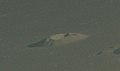 Mairan T from Apollo 15
.png)

References
- USGS Professional Paper 1348. By Don E. Wilhelms, John F. McCauley, and Newell J. Trask. U.S. Government Printing Office, Washington: 1987. Table 11.2.
- ^ Geology of Mairan middle dome: Its implication to silicic volcanism on the Moon
- ^ "Mairan". Gazetteer of Planetary Nomenclature. USGS Astrogeology Research Program.
- Bibcode:2011LPI....42.2228T.
- ISBN 9788847026377.
- ^ The Mairan domes: Silicic volcanic constructs on the Moon
- Andersson, L. E.; Whitaker, E. A. (1982). NASA Catalogue of Lunar Nomenclature (PDF). NASA RP-1097. Archived from the original on 2014-10-06.
{{cite book}}: CS1 maint: bot: original URL status unknown (link) - Blue, Jennifer (July 25, 2007). "Gazetteer of Planetary Nomenclature". USGS. Retrieved 2015-12-31.
- ISBN 978-0-521-81528-4.
- Cocks, Elijah E.; Cocks, Josiah C. (1995). Who's Who on the Moon: A Biographical Dictionary of Lunar Nomenclature. Tudor Publishers. ISBN 978-0-936389-27-1.
- McDowell, Jonathan (July 15, 2007). "Lunar Nomenclature". Jonathan's Space Report. Retrieved 2007-10-24.
- Menzel, D. H.; Minnaert, M.; Levin, B.; Dollfus, A.; Bell, B. (1971). "Report on Lunar Nomenclature by the Working Group of Commission 17 of the IAU". Space Science Reviews. 12 (2): 136–186. S2CID 122125855.
- ISBN 978-0-304-35469-6.
- Price, Fred W. (1988). The Moon Observer's Handbook. Cambridge University Press. ISBN 978-0-521-33500-3.
- ISBN 978-0-913135-17-4.
- ISBN 978-0-486-20917-3.
- ISBN 978-0-521-54414-6.
- Wlasuk, Peter T. (2000). Observing the Moon. Springer Science & Business Media. ISBN 978-1-852-33193-1.