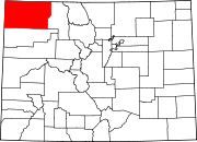
Massadona, Colorado
Appearance
Massadona is an
History
Massadona was founded sometime prior to 1907, and was known as Boxelder. Although the origin of the name Massadona is unknown, it is possible that the original name of Boxelder came from a local creek, which is called Box Elder Creek. The name was changed between 1910 and 1954, possibly to avoid confusion with Box Elder in Adams County.[2]
The post office in Dinosaur serves Massadona addresses.[3]
Climate
According to the
cold semi-arid climate, abbreviated "BSk" on climate maps. The hottest temperature recorded in Massadona was 102 °F (38.9 °C) on July 21, 2005, while the coldest temperature recorded was −29 °F (−33.9 °C) on December 22, 1990.[4]
| Climate data for Massadona, Colorado, 1991–2020 normals, extremes 1986–2009 | |||||||||||||
|---|---|---|---|---|---|---|---|---|---|---|---|---|---|
| Month | Jan | Feb | Mar | Apr | May | Jun | Jul | Aug | Sep | Oct | Nov | Dec | Year |
| Record high °F (°C) | 56 (13) |
62 (17) |
77 (25) |
81 (27) |
95 (35) |
96 (36) |
102 (39) |
100 (38) |
93 (34) |
82 (28) |
68 (20) |
62 (17) |
102 (39) |
| Mean daily maximum °F (°C) | 33.0 (0.6) |
38.9 (3.8) |
50.8 (10.4) |
59.2 (15.1) |
68.7 (20.4) |
81.6 (27.6) |
88.3 (31.3) |
86.0 (30.0) |
76.5 (24.7) |
62.1 (16.7) |
46.7 (8.2) |
33.7 (0.9) |
60.5 (15.8) |
| Daily mean °F (°C) | 22.4 (−5.3) |
27.1 (−2.7) |
38.3 (3.5) |
45.6 (7.6) |
55.0 (12.8) |
65.7 (18.7) |
72.6 (22.6) |
70.4 (21.3) |
61.4 (16.3) |
48.5 (9.2) |
35.4 (1.9) |
22.8 (−5.1) |
47.1 (8.4) |
| Mean daily minimum °F (°C) | 11.8 (−11.2) |
15.3 (−9.3) |
25.8 (−3.4) |
32.0 (0.0) |
41.3 (5.2) |
49.7 (9.8) |
56.9 (13.8) |
54.8 (12.7) |
46.3 (7.9) |
34.9 (1.6) |
24.0 (−4.4) |
12.0 (−11.1) |
33.7 (1.0) |
| Record low °F (°C) | −7 (−22) |
−25 (−32) |
−8 (−22) |
7 (−14) |
20 (−7) |
28 (−2) |
41 (5) |
37 (3) |
22 (−6) |
0 (−18) |
−8 (−22) |
−29 (−34) |
−29 (−34) |
| Average precipitation inches (mm) | 1.09 (28) |
1.03 (26) |
1.25 (32) |
1.32 (34) |
1.59 (40) |
0.85 (22) |
0.97 (25) |
0.96 (24) |
1.56 (40) |
1.63 (41) |
1.04 (26) |
1.08 (27) |
14.37 (365) |
| Average snowfall inches (cm) | 13.3 (34) |
8.1 (21) |
4.6 (12) |
2.9 (7.4) |
1.0 (2.5) |
0.0 (0.0) |
0.0 (0.0) |
0.0 (0.0) |
0.0 (0.0) |
4.3 (11) |
6.9 (18) |
10.1 (26) |
51.2 (131.9) |
| Average precipitation days (≥ 0.01 in) | 7.5 | 7.4 | 6.6 | 8.5 | 8.0 | 5.7 | 4.9 | 7.0 | 6.7 | 6.6 | 5.7 | 5.6 | 80.2 |
| Average snowy days (≥ 0.1 in) | 6.6 | 5.5 | 3.1 | 2.2 | 0.4 | 0.0 | 0.0 | 0.0 | 0.0 | 1.5 | 3.9 | 4.8 | 28.0 |
| Source 1: NOAA[5] | |||||||||||||
| Source 2: XMACIS2[4] | |||||||||||||
References
- ^ "Massadona". Geographic Names Information System. United States Geological Survey, United States Department of the Interior. Retrieved September 29, 2021.
- ^ "TopoView". Retrieved September 5, 2021.
- ^ "United States Zip Codes". Retrieved September 5, 2021.
- ^ a b "xmACIS2". National Oceanic and Atmospheric Administration. Retrieved July 7, 2023.
- ^ "U.S. Climate Normals Quick Access – Station: Massadona 3E, CO". National Oceanic and Atmospheric Administration. Retrieved July 7, 2023.
40°15′10″N 108°38′25″W / 40.25278°N 108.64028°W

