
Medway watermills
Watermills of the River Medway and its tributaries | ||||||||||||||||||||||||||||||||||||||||||||||||||||||||||||||||||||||||||||||||||||||||||||||||||||||||||||||||||||||||||||||||||||||||||||||||||||||||||||||||||||||||||||||||||||||||||||||||||||||||||||||||||||||||||||||||||||||||||||||||||||||||||||||||||||||||||||||||||||||||||||||||||||||||||||||||||||||||||||||||||||||||||||||||||||||||||||||||||||||||||||||||||||||||||||||||||||||||||||||||||||||||||||||||||||||||||||||||||||||||||||||||
|---|---|---|---|---|---|---|---|---|---|---|---|---|---|---|---|---|---|---|---|---|---|---|---|---|---|---|---|---|---|---|---|---|---|---|---|---|---|---|---|---|---|---|---|---|---|---|---|---|---|---|---|---|---|---|---|---|---|---|---|---|---|---|---|---|---|---|---|---|---|---|---|---|---|---|---|---|---|---|---|---|---|---|---|---|---|---|---|---|---|---|---|---|---|---|---|---|---|---|---|---|---|---|---|---|---|---|---|---|---|---|---|---|---|---|---|---|---|---|---|---|---|---|---|---|---|---|---|---|---|---|---|---|---|---|---|---|---|---|---|---|---|---|---|---|---|---|---|---|---|---|---|---|---|---|---|---|---|---|---|---|---|---|---|---|---|---|---|---|---|---|---|---|---|---|---|---|---|---|---|---|---|---|---|---|---|---|---|---|---|---|---|---|---|---|---|---|---|---|---|---|---|---|---|---|---|---|---|---|---|---|---|---|---|---|---|---|---|---|---|---|---|---|---|---|---|---|---|---|---|---|---|---|---|---|---|---|---|---|---|---|---|---|---|---|---|---|---|---|---|---|---|---|---|---|---|---|---|---|---|---|---|---|---|---|---|---|---|---|---|---|---|---|---|---|---|---|---|---|---|---|---|---|---|---|---|---|---|---|---|---|---|---|---|---|---|---|---|---|---|---|---|---|---|---|---|---|---|---|---|---|---|---|---|---|---|---|---|---|---|---|---|---|---|---|---|---|---|---|---|---|---|---|---|---|---|---|---|---|---|---|---|---|---|---|---|---|---|---|---|---|---|---|---|---|---|---|---|---|---|---|---|---|---|---|---|---|---|---|---|---|---|---|---|---|---|---|---|---|---|---|---|---|---|---|---|---|---|---|---|---|---|---|---|---|---|---|---|---|---|---|---|---|---|---|---|---|---|---|---|---|---|---|---|---|---|---|---|---|---|---|---|---|---|---|---|---|---|---|---|---|---|---|---|---|---|---|---|---|---|---|---|---|---|---|---|---|---|---|
| ||||||||||||||||||||||||||||||||||||||||||||||||||||||||||||||||||||||||||||||||||||||||||||||||||||||||||||||||||||||||||||||||||||||||||||||||||||||||||||||||||||||||||||||||||||||||||||||||||||||||||||||||||||||||||||||||||||||||||||||||||||||||||||||||||||||||||||||||||||||||||||||||||||||||||||||||||||||||||||||||||||||||||||||||||||||||||||||||||||||||||||||||||||||||||||||||||||||||||||||||||||||||||||||||||||||||||||||||||||||||||||||||
The
Watermills
The River Medway powered a number of watermills. From source to mouth they were:
Fen Place (Bishes) Mill, Worth
TQ 361 366 51°06′45″N 0°03′17″W / 51.112421°N 0.054732°W The
Mill Place Foundry, East Grinstead
Another gun foundry site.[1][7]
Brambletye (Castle) Mill, Forest Row.
TQ 4168 3527 51°05′55″N 0°01′26″E / 51.098721°N 0.023758°E A
Tablehurst Mill, Forest Row
TQ 450 352 51°05′52″N 0°04′18″E / 51.097655°N 0.071779°E This mill was a mainly sixteenth century building. It is most likely to be the "Tellhurst Mill" that J. M. W. Turner sketched c.1795. It had two overshot waterwheels in tandem, with all wooden machinery. The mill ceased working in 1925 and had been demolished by 1936.A[9]
Parrock Forge, Hartfield
TQ 458 357 51°06′07″N 0°05′00″E / 51.101945°N 0.083399°E This forge was active during the reign of
Hartfield Iron Mill
This forge was in existence in 1496, when its owner Thomas Wildgoose made his will. Its probable location was below Chartners Farm (square TQ4736).[11][13]
Ashurst Mill
TQ 506 389 51°07′46″N 0°09′12″E / 51.129461°N 0.153251°E This mill was a
Ashurst Furnace
TQ 507 390 51°07′49″N 0°09′17″E / 51.130334°N 0.154721°E This furnace stood just downstream of Ashurst Mill. It was operating between 1574 and 1599. It was owned by someone by the name of Stace in 1574, Sir Walter Waller in 1588–90 (occupied by John Phillips) and in 1599 Thomas Browne sold cannon here.[12][15][16][17]
Chafford Mills, Fordcombe
This was a
Pound Mill, Penshurst
This mill stood below Ford Place Farm. It was a corn mill powered by an overshot waterwheel.A[21]
Ensfield Mill
A long lost mill site. An agreement between Tonbridge Priory and the bishop of Rochester in 1353 mentions a mill at "Yenesfield" - the present day Ensfield Farm.A
Ramhurst Mill, Leigh
TQ 566 463 51°11′38″N 0°14′31″E / 51.194°N 0.242°E In the 1428 will of Sir Thomas Colepeper it is referred to as the mill of Greenerssh. The mill was marked on a map dated 1579.[22] The mill was marked as Crenhurst Mill on a map of 1769.[23] Ramshurst Mill was marked on the 1801 Ordnance Survey map,[24] but not on Greenwoods map dated 1821.[25] In 1851, Henry Morgan was a millwright living at Ramhurst Mills, Leigh.A[26][27]
Powder Mills, Leigh (Tunbridge Gunpowder Works)
TQ 573 466 51°11′49″N 0°15′08″E / 51.196853°N 0.252305°E This was a
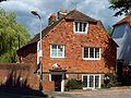
Town Mill, Tonbridge
TQ 596 467 51°11′50″N 0°17′07″E / 51.197113°N 0.285244°E An old corn mill site. The mill house survives along with a few walls of the mill, which had a breastshot waterwheel.A[21] In 2006 Tonbridge Civic Society gave an award to a new-build house that incorporated the mill remains.[31]
-
 The Mill House
 -
 The new building on the old walls

.JPG)
Branbridges Mill, East Peckham
TQ 673 485 51°12′40″N 0°23′46″E / 51.211083°N 0.396201°E This mill was known as "Brantbridge Mill" in 1538, being then valued at £2.6s.8d., owned by Sir Thomas Wyatt. In later years it was run by the Arnold family, who were previously at Bartley Mill, Frant. They took the mill in 1890, and the mill was marked as an oil mill on that year's 25" Ordnance Survey map. The waterwheel was replaced by a turbine, then that was replaced by a gas engine, in turn being replaced by an oil engine. Flour production ceased c.1917 and provender milling ceased c.1947. The mill was burnt down in the 1960s.A[32]
Hampstead Mill, Yalding
TQ 688 501 approx 51°13′30″N 0°25′06″E / 51.225017°N 0.418411°E One of two Domesday sites in Yalding, this was a paper mill in 1872.[33] The site was first used as a chemical works just before the First World War, and eventually became part of ICI.A[34][35]
Friars Mill, Aylesford
This was a corn mill, serving Aylesford Friary.A[21]
Borstal Mill
An old tide mill site. The mill was the property of the See of Rochester in 1323, being rebuilt by Hamo de Hethe in that year.A
Cuxton Mill.
This was a tide mill.A
Priory Mill, Rochester
This was a tide mill. It stood at the end of George Lane near the town walls. The mill was demolished in the seventeenth century.A
Strood Tide Mill
TQ 740 690 51°23′36″N 0°29′59″E / 51.393357°N 0.499625°E The site of this mill is marked by Water Mill Wharf, north of the railway bridge. It belonged to Temple Strood Manor and in the mid-fourteenth century contained "two water mills under one roof". An engraving by S & N Buck dated 1721 shows the mill, and it appears in "A Distant View of Rochester and Chatham" by Joshua Farington, RA, in 1790. A sketch by W H Reynolds shows the mill in greater detail, and was done at a later date. The mill had two undershot waterwheels and was valued in the Church Rate Books of 1764 at £64.1s.1d. Latterly a steam engine was installed to enable the mill to work for longer periods.A The mill was demolished in 1858. Latterly it drove five pairs of millstones, one wheel worked two pairs of French Burr stones and one pair of Peak stones. The other wheel worked two pairs of French Burr stones, wheat cleaners, flour dressers and the sack hoist.[36]
Chatham Tide Mill
TQ 757 683 51°23′12″N 0°31′25″E / 51.386546°N 0.523689°E There was a tide mill marked on 1575/1610 maps of the Brook area of Chatham, where the Old Bourne River entered the Medway. By 1765, the Mill is not on the map and the river had been canalised, running alongside the road known as the Brook, and soon after it had been culverted.[37]
Watermills on the tributaries
The vast majority of the watermills were on the tributaries. The watermills on the tributaries feeding in above Penshurst are covered in the upper tributaries article, while those watermills on the tributaries feeding in between Penshurst and Yalding are covered in the middle tributaries article. Those on the tributaries feeding in below Yalding are covered in the lower tributaries article.
Sources
References
- ^ a b The Weald
- ^ Right Move
- ^ Ashdown Rambling Club Archived 2005-01-16 at the Wayback Machine
- ^ Kellys Directory Archived 2005-05-24 at the Wayback Machine entry for East Grinstead
- ^ 1841 Census
- ^ 1851 Census
- ^ The Weald
- ^ Sussex Mills Group
- ^ Sussex Mills Group
- ^ The Weald
- ^ a b The Weald
- ^ a b Wealden Iron Research Group enter name of forge in search box
- ^ The Weald
- ^ Roughwood
- ^ a b The Weald
- ^ The Weald
- ^ Iron Furnaces
- ^ BAPH Archived 2007-10-22 at the Wayback Machine
- ^ Easily Archived 2008-10-01 at the Wayback Machine
- ^ Stamp Notes
- ^ a b c d Mills Archive Archived 2010-04-18 at the Wayback Machine
- ^ a b c d e "The Powder Mill - Leigh: Historical Notes" (PDF). Leigh Historical Society. Archived from the original (PDF) on 19 August 2011. Retrieved 10 June 2008.'(PDF)
- ^ "Andrew, Drury and Herbert's Map, 1769". Leigh Historical Society. Archived from the original on 24 December 2012. Retrieved 10 June 2008.
- ^ "1801 Ordnance Survey". Leigh Historical Society. Archived from the original on 24 December 2012. Retrieved 9 June 2008.
- ^ a b "Greenwoods Map of Kent, 1821". Leigh Historical Society. Archived from the original on 24 December 2012. Retrieved 9 June 2008.
- ^ 1851 Census Archived 2007-12-21 at archive.today
- ^ Colepepper
- ^ Colepepper Will
- ^ Rootsweb
- ^ "Powdermills, 1837". Leigh Historical Society. Archived from the original on 24 December 2012. Retrieved 10 June 2008.
- ^ "Civic Design Award for Tonbridge Mill". Tonbridge Civic Society. Retrieved 15 July 2008.
- ^ "Mills Archive". Archived from the original on 14 July 2011. Retrieved 7 February 2008.
- ^ 1872 1:10,560 Ordnance Survey map.
- ^ Spartacus Educational Archived 2008-03-08 at the Wayback Machine
- ^ Yalding Chronology
- ^ Coles Finch, William (1925). In Kentish Pilgrim Land. London: C W Daniel. p. 269.
- ^ "History of the Brook Pumping Station". Medway Industrial Archaeology Group. Archived from the original on 15 April 2009. Retrieved 7 May 2009.
Further reading
- Donald Maxwell. Unknown Kent (G. P. Putnam's sons, 1922) pp. 13–32.