
Minlaton, South Australia
| Minlaton Federal division(s) | Grey[5] | ||||||||||||||
|---|---|---|---|---|---|---|---|---|---|---|---|---|---|---|---|
| |||||||||||||||
| Footnotes | Adjoining localities[1] | ||||||||||||||
Minlaton is a town in central Yorke Peninsula, South Australia. It is known as the "Barley capital of the world", due to the rich Barley production in the region.
Minlaton was the hometown of
air mail run from Adelaide across Gulf St Vincent to Minlaton in 1919, it was the first over-water flight in the Southern Hemisphere
.
Minlaton is in the
Climate
Minlaton, like most of the Yorke Peninsula, has a dry mediterranean climate bordering on semi-arid. Annual rainfall is around 360 millimetres or 14 inches, most of which falls in the winter months.[citation needed]
| Climate data for Minlaton Aero | |||||||||||||
|---|---|---|---|---|---|---|---|---|---|---|---|---|---|
| Month | Jan | Feb | Mar | Apr | May | Jun | Jul | Aug | Sep | Oct | Nov | Dec | Year |
| Record high °C (°F) | 45.6 (114.1) |
44.1 (111.4) |
41.0 (105.8) |
37.4 (99.3) |
30.9 (87.6) |
25.9 (78.6) |
23.0 (73.4) |
29.3 (84.7) |
33.0 (91.4) |
38.7 (101.7) |
44.3 (111.7) |
45.9 (114.6) |
45.6 (114.1) |
| Mean daily maximum °C (°F) | 29.6 (85.3) |
28.6 (83.5) |
26.7 (80.1) |
23.4 (74.1) |
19.5 (67.1) |
16.3 (61.3) |
15.3 (59.5) |
16.4 (61.5) |
19.1 (66.4) |
22.6 (72.7) |
26.0 (78.8) |
27.6 (81.7) |
22.6 (72.7) |
| Mean daily minimum °C (°F) | 15.4 (59.7) |
15.3 (59.5) |
14.1 (57.4) |
11.9 (53.4) |
10.0 (50.0) |
7.8 (46.0) |
7.0 (44.6) |
6.8 (44.2) |
7.9 (46.2) |
9.3 (48.7) |
12.0 (53.6) |
13.5 (56.3) |
10.9 (51.6) |
| Record low °C (°F) | 6.4 (43.5) |
8.0 (46.4) |
6.0 (42.8) |
5.0 (41.0) |
3.0 (37.4) |
0.0 (32.0) |
−0.3 (31.5) |
0.5 (32.9) |
0.2 (32.4) |
0.8 (33.4) |
2.1 (35.8) |
3.7 (38.7) |
−0.3 (31.5) |
| Average precipitation mm (inches) | 14.5 (0.57) |
18.1 (0.71) |
16.1 (0.63) |
24.5 (0.96) |
39.5 (1.56) |
52.5 (2.07) |
50.0 (1.97) |
46.1 (1.81) |
35.4 (1.39) |
22.8 (0.90) |
21.8 (0.86) |
19.6 (0.77) |
360.3 (14.19) |
| Average precipitation days (≥ 0.2 mm) | 4.6 | 3.4 | 5.2 | 8.6 | 13.1 | 17.6 | 18.5 | 18.6 | 14.6 | 8.3 | 6.9 | 6.9 | 126.3 |
| Average afternoon relative humidity (%)
|
36 | 39 | 40 | 47 | 49 | 67 | 70 | 63 | 58 | 47 | 39 | 39 | 50 |
| Source: [7] | |||||||||||||
Gallery
-
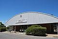
 Harry Butler's Red Devil is on display in Minlaton
 -
 Harry Butler memorial
 -
 Main street
 -
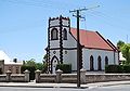 St Benedict's Anglican church, built in 1886


See also
References
- ^ a b c d e "Search results for 'Minlaton, LOCB' with the following datasets selected - 'Suburbs and localities', 'Counties', 'Government Towns','Local Government Areas', 'SA Government Regions' and 'Gazetteer'". Location SA Map Viewer. Government of South Australia. Retrieved 15 December 2022.
- ^ Australian Bureau of Statistics (28 June 2022). "Minlaton (urban centre and locality)". Australian Census 2021.
- AustLII
- ^ a b Narungga (Map). Electoral District Boundaries Commission. 2016. Retrieved 1 March 2018.
- ^ "Federal electoral division of Grey" (PDF). Australian Electoral Commission. Retrieved 24 July 2015.
- ^ "Localities". Australian Electoral Commission. Archived from the original on 6 July 2011. Retrieved 13 July 2010.
- ^ "MINLATON AERO (nearest Weather Station)". Climate statistics for Australian locations. Commonwealth of Australia , Bureau of Meteorology. Retrieved 13 December 2022.
External links
Wikimedia Commons has media related to Minlaton, South Australia.
- Yorke Peninsula: Minlaton
- Harvest Corner website Yorke Peninsula Visitor Information Centre at Minlaton
| Major Townships | |||||||
|---|---|---|---|---|---|---|---|
| Minor Townships | |||||||
| Governance |
| ||||||
| Coastal features | |||||||
| Protected areas |
| ||||||
| Adjacent islands | |||||||
| Related and uncategorised | |||||||