
Kadina, South Australia
| Kadina Federal division(s) | Grey | ||||||||||||||
|---|---|---|---|---|---|---|---|---|---|---|---|---|---|---|---|
| |||||||||||||||
| |||||||||||||||
Kadina (
Kadina's surrounds form an important agricultural base for the region, and are used for growing cereal crops. Kadina used to be a mining town but now the majority of Kadina's land is used for farming.
Description
Kadina is about 20 kilometres (12 mi) north-east of Moonta and 8 kilometres (5.0 mi) east of the port town of Wallaroo. There are 6 suburbs making up Kadina's township, each being a distinct historic locality or hamlet. These are: Jericho, Jerusalem, Matta Flat, New Town and Wallaroo Mines as well as central Kadina itself.[3] Kadina East was previously a gazetted suburb east of Kadina's centre, later merged into Kadina itself.[3]
History
Aboriginal
The Narungga are the group of Indigenous Australians whose traditional lands include what is now termed Yorke Peninsula in South Australia. The name "Kadina" is thought to be derived from Kadiyinya, a Narungga word meaning 'Lizard Plain'.
European
Copper was discovered at
In 1862, the
In 1872 Kadina became a municipality by establishment of the Corporate Town of Kadina. By 1875, the population had increased to 20,000, mostly composed of Cornish miners.[citation needed] In 1907 the adjacent Government Town of Kadina East was surveyed west of Eliza Terrace to cope with the need to house the growing population of the town.[7]
Mining at Kadina ceased completely in 1938, and the rail lines fell into disuse and were closed in 1989.
Heritage listings
Kadina has a number of heritage-listed sites, including:
- Drain Road: Kadina Cemetery[8]
- 36-38 Taylor Street: Humphries Barber Shop[9]
- 51 Taylor Street: Kadina Town Hall[10]
Geography and climate
Kadina has a semi-arid climate (Köppen: BSk), with moderately hot, dry summers and cool, wetter winters. The town is above Goyder's Line, and is surrounded by mallee scrub. It is located 8 km (5.0 mi) inland and 44 m (144 ft) above sea level. Temperatures vary throughout the year, with average maxima ranging from 30.5 °C (86.9 °F) in January to 15.5 °C (59.9 °F) in July, and average minima fluctuating between 15.8 °C (60.4 °F) in February and 5.7 °C (42.3 °F) in July. Annual precipitation is rather low, averaging 388.6 mm (15.30 in) between 92.3 precipitation days. There are 122.3 clear days and 102.6 cloudy days annually.[11] Extreme temperatures have ranged from 47.9 °C (118.2 °F) on 24 January 2019 to −2.9 °C (26.8 °F) on 30 August 2019.[12] Extremes were combined from the closed Kadina weather station and the current Kadina AWS station.
| Climate data for Kadina (33º57'36"S, 137º42'00"E, 44 m AMSL) (1876-2005 normals, extremes 1957-2024) | |||||||||||||
|---|---|---|---|---|---|---|---|---|---|---|---|---|---|
| Month | Jan | Feb | Mar | Apr | May | Jun | Jul | Aug | Sep | Oct | Nov | Dec | Year |
| Record high °C (°F) | 47.9 (118.2) |
45.2 (113.4) |
42.1 (107.8) |
38.0 (100.4) |
30.5 (86.9) |
26.1 (79.0) |
24.2 (75.6) |
29.1 (84.4) |
35.0 (95.0) |
38.9 (102.0) |
44.6 (112.3) |
46.0 (114.8) |
47.9 (118.2) |
| Mean daily maximum °C (°F) | 30.5 (86.9) |
30.1 (86.2) |
27.4 (81.3) |
23.8 (74.8) |
19.3 (66.7) |
16.6 (61.9) |
15.5 (59.9) |
16.6 (61.9) |
19.5 (67.1) |
22.8 (73.0) |
25.8 (78.4) |
27.7 (81.9) |
23.0 (73.3) |
| Mean daily minimum °C (°F) | 15.7 (60.3) |
15.8 (60.4) |
13.8 (56.8) |
11.3 (52.3) |
8.5 (47.3) |
7.1 (44.8) |
5.7 (42.3) |
6.0 (42.8) |
7.4 (45.3) |
9.4 (48.9) |
11.9 (53.4) |
13.8 (56.8) |
10.5 (50.9) |
| Record low °C (°F) | 6.7 (44.1) |
6.7 (44.1) |
3.6 (38.5) |
1.2 (34.2) |
−0.8 (30.6) |
−2.8 (27.0) |
−2.8 (27.0) |
−2.9 (26.8) |
−2.6 (27.3) |
−0.2 (31.6) |
1.3 (34.3) |
4.6 (40.3) |
−2.9 (26.8) |
| Average precipitation mm (inches) | 14.9 (0.59) |
18.2 (0.72) |
19.1 (0.75) |
32.5 (1.28) |
45.8 (1.80) |
51.8 (2.04) |
48.5 (1.91) |
45.3 (1.78) |
38.9 (1.53) |
33.2 (1.31) |
22.5 (0.89) |
17.8 (0.70) |
388.6 (15.30) |
| Average precipitation days (≥ 0.2 mm) | 3.2 | 2.9 | 3.8 | 6.5 | 10.0 | 12.1 | 13.1 | 12.6 | 10.0 | 8.1 | 5.6 | 4.4 | 92.3 |
| Average afternoon relative humidity (%)
|
36 | 37 | 40 | 47 | 59 | 63 | 65 | 60 | 53 | 44 | 40 | 38 | 49 |
| Average dew point °C (°F) | 11.5 (52.7) |
11.7 (53.1) |
10.3 (50.5) |
9.9 (49.8) |
9.6 (49.3) |
8.3 (46.9) |
7.8 (46.0) |
7.5 (45.5) |
8.6 (47.5) |
7.7 (45.9) |
8.3 (46.9) |
10.1 (50.2) |
9.3 (48.7) |
| Source: Bureau of Meteorology (1876-2005 normals, extremes 1957-2024)[13][14] | |||||||||||||
Governance
Kadina is located within the local government area of the Copper Coast Council,[3] which was formed in 1997. The Copper Coast Council replaced the District Council of Kadina, which existed from 1888 to 1984, and the District Council of Northern Yorke Peninsula. The Corporate Town of Kadina, which had existed since 1872, was previously merged into the District Council of Kadina in 1977.
Kadina is part of the federal division of Grey and lies within the state electoral district of Narungga.[15][2]
Local economy
Mining
Kadina was once chiefly a copper mining town with the
Broadacre cropping
Kadina is surrounded by lands used for broadacre cereal cropping. Staples such as
Tourism
The town today consists of important historical colonial and federation buildings gathered around Victoria Square. Kadina also contains the Farm Shed Museum & Tourism Centre (Kadina Heritage Museum) and remnants of the
Transport
The Copper Coast Highway passes through Kadina. The town was formerly the Junction of the now disused Balaklava–Moonta railway line with the Kadina–Brinkworth line. Both of these lines closed to regular service in 1993, with the Wallaroo to Kadina section of former converted to a rail trail in 2009. Nearby Kadina Airport caters to small private aircraft and emergency services.
Media
The town serves as the base for local radio station Gulf FM, broadcasting at 89.3 FM. The Yorke Peninsula Country Times newspaper is based in Kadina.
Notable people
- Oliver Badman (1885–1977), politician
- Richard Champion (b. 1968), former AFL footballer
- Lynton Crosby (b.1957), political strategist
- John Olsen (b. 1945), former South Australian Premier and South Australian Federal Senator
- Rex Pearson (1905–1961), politician
- Steve Prestwich (1954–2011), musician
- Cameron Sutcliffe(b.1992), AFL Footballer
- Horace Wilson (1864–1923), cricketer
- Leslie Heath (1902–1957), politician
Gallery
-
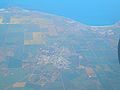 Aerial view of Kadina (centre, inland), looking west toward Spencer Gulf
 -
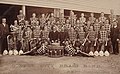
 Miners, 1900
 -
 Copper City Brass Band, 1907
 -
 Shops in Graves Street, Kadina
 -
 Banking & Currency Museum
 -
 Introduced snails


See also
- Wallaroo, South Australia
- Moonta, South Australia
- Cornish emigration
- Kernewek Lowender
References
- ^ Australian Bureau of Statistics (28 June 2022). "Kadina (urban centre and locality)". Australian Census 2021.
- ^ a b Narungga (Map). Electoral District Boundaries Commission. 2016. Retrieved 1 March 2018.
- ^ a b c "Placename Details: Kadina". Property Location Browser. Government of South Australia. 21 March 2013. SA0033380. Archived from the original on 7 December 2015. Retrieved 17 November 2017.
Derivation of Name: See Hundred of Kadina; Other Details: Town surveyed in January 1861, no proclamation. Boundaries created in January 1999 for the long established name. Incorporates the Government Towns of Kadina and Kadina East. Anglicised version of the Narungga name Gardina for a camp in this area.
- ^ "PORT WALLAROO. From our own Correspondent (July 7)". South Australian Weekly Chronicle. 12 July 1862. p. 3.
- ^ "THE KADINA AND BARUNGA RAILWAY". South Australia Chronicle and Weekly Mail. 8 March 1879. p. 7.
- ^ Callaghan, W.H. (February 2002). "Horse and Steam, Wheat and Copper". Australian Railway Historical Society Bulletin: 9–27, 46–63.
- ^ "Placename Details: Kadina East". Property Location Browser. Land Services, Government of South Australia. 12 May 2011. SA0033385. Archived from the original on 7 December 2015. Retrieved 8 November 2017.
Derivation of Name: Proximity to the town of Kadina; Other Details: Town surveyed in May 1907. Now incorporated in the bounded locality of Kadina.
- ^ "Kadina Cemetery, including the Mortuary and Wall". South Australian Heritage Register. Department of Environment, Water and Natural Resources. Retrieved 17 May 2016.
- ^ "Former Humphries Barber Shop (former Hancock's Barber Shop and Billiard Saloon)". South Australian Heritage Register. Department of Environment, Water and Natural Resources. Retrieved 17 May 2016.
- ^ "Kadina Town Hall (incorporating 1880 Mechanics Institute)". South Australian Heritage Register. Department of Environment, Water and Natural Resources. Retrieved 17 May 2016.
- ^ "Kadina Climate (1876-2005)". FarmOnline Weather. Retrieved 10 August 2024.
- ^ "Kadina AWS Climate (2005-2024)". FarmOnline Weather. Retrieved 10 August 2024.
- ^ "Kadina Climate Statistics (1876-2005)". Bureau of Meteorology. Retrieved 10 August 2024.
- ^ "Kadina AWS Climate Statistics (2005-2024)". Bureau of Meteorology. Retrieved 10 August 2024.
- ^ "Federal electoral division of Grey" (PDF). Australian Electoral Commission. Retrieved 24 July 2015.
External links
| Major Townships | |||||||
|---|---|---|---|---|---|---|---|
| Minor Townships | |||||||
| Governance |
| ||||||
| Coastal features | |||||||
| Protected areas |
| ||||||
| Adjacent islands | |||||||
| Related and uncategorised | |||||||