
Mocho-Choshuenco National Reserve
This article needs additional citations for verification. (June 2012) |
| Mocho-Choshuenco National Reserve | |
|---|---|
Corporación Nacional Forestal |
The Mocho-Choshuenco National Reserve (Pronounced: municipality.
The principal access goes from the Pan American Highway to Enco passing by Panguipulli and Choshuenco. From Enco a small way goes to the refuge area, during the summer months tracked vehicles can go there.
Mocho-Choshuenco National Reserve has no park guards or any public infrastructure. In the refuge sector there is a mountain hut leased to Los Lagos municipality, some old military buildings ruins, and the rests of a small ski centre.
Gallery
-
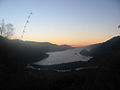 Sunset on Riñihue Lake, view from Mocho-Choshuenco
 -
 Río Blanco Valley. Río Blanco river drains the west side of Mocho-Choshuenco to the Enco River.


References
- ^ "Mocho-Choshuenco National Reserve". protectedplanet.net.
External links
- (in Spanish) A specialized blog about Mocho-Choshuenco National Reserve at mochochoshuenco.blogspot.com
This Los Ríos Region location article is a stub. You can help Wikipedia by expanding it. |
This article related to a protected area in South America is a stub. You can help Wikipedia by expanding it. |