Moiremont
Moiremont | |
|---|---|
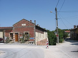
 The town hall in Moiremont | |
| Coordinates: 49°08′01″N 4°53′17″E / 49.1336°N 4.8881°E | |
| Country | France |
| Region | Grand Est |
| Department | Marne |
| Arrondissement | Châlons-en-Champagne |
| Canton | Argonne Suippe et Vesle |
| Intercommunality | Argonne Champenoise |
| Government | |
| • Mayor (2020–2026) | Patrick Desingly[1] |
| Area 1 | 16.98 km2 (6.56 sq mi) |
| Population (2021)[2] | 190 |
| • Density | 11/km2 (29/sq mi) |
| Time zone | UTC+01:00 (CET) |
| • Summer (DST) | UTC+02:00 (CEST) |
| INSEE/Postal code | 51370 /51800 |
| 1 French Land Register data, which excludes lakes, ponds, glaciers > 1 km2 (0.386 sq mi or 247 acres) and river estuaries. | |
Moiremont (French pronunciation: [mwaʁmɔ̃]) is a commune in the Marne department in north-eastern France.
Places & Monuments
- Moiremont abbey is a former Benedictine abbey founded in 707 in the form of a congregation. In 1074, Reims' Archbishop, Manasses II sent benedictions and gave a foundation chart on Odalric's demand.
Pierre Pérignon, born in Sainte-Menehould in 1639, joined the congregation when he was around 16 before joining Saint-Vannes abbey in Verdun where he became a monk under the famous name Dom Pérignon.
The only remaining part of the abbey to this day is the Abbatial church which was reformed into a Parochial church after the French Revolution. - Saint-Placide wash house.
- Timber framing houses.
See also
References
- ^ "Répertoire national des élus: les maires" (in French). data.gouv.fr, Plateforme ouverte des données publiques françaises. 13 September 2022.
- ^ "Populations légales 2021". The National Institute of Statistics and Economic Studies. 28 December 2023.
Wikimedia Commons has media related to Moiremont.


