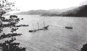
Moltke (1870)
 Wreck of the Moltke (Early 20th Century)
| |
| History | |
|---|---|
| Name | Moltke |
| Owner |
|
| Builder | Godeffroy-Zeit, Hamburg |
| Yard number | 216 |
| Completed | 1870 |
| Out of service | 1911 |
| Fate |
|
| General characteristics | |
| Type | Three-masted Iron hulled Barque |
| Tonnage | 828 NRT |
| Beam | 9.8 m |
| Crew | 14 (1890) |
The Moltke was a three-masted barque built in
Hamburg, Germany in 1870. The vessel was wrecked off the coast of northern Queensland, Australia in 1890 before being refloated and hulked. In 1911 the vessel was scuttled off Geoffrey Bay, Magnetic Island
. The wreck of the vessel now hosts a wide range of underwater life and is a popular open-water dive site.
History
Built by
Cape Bowling Green, the vessel ran aground upon a reef. The crew abandoned the vessel and returned to Townsville.[2]
The vessel was refloated and towed back to Townsville port by the
hulk. In 1911, Dr McCabe, a local dentist who owned property at Geoffrey Bay purchased the hulk with the intent to scuttle the vessel to protect the jetty located in the bay. An explosives expert, William Bright, was contracted to sink the vessel. Accounts of the event suggest that while the vessel was being towed into place, the fuse for the explosives was lit prematurely by an intoxicated Bright. The tug boat pilot was able to release the tow lines and pilot clear of the vessel. However, the explosives aboard the vessel detonated and scuttled the boat in the wrong location and 10m depth.[2]
References
- ^ "Single Ship Report for "5617929"". Miramar Ship Index. Retrieved 8 January 2010.
- ^ a b c d "Shipwrecks Audio Transcript » SS Moltke". Australian Broadcasting Corporation. Retrieved 8 January 2010.
- ^ a b "Encyclopedia of Australian Shipwrecks - Queensland". Encyclopedia of Australian Shipwrecks. Archived from the original on 2 October 2009. Retrieved 8 January 2010.
