
Monastyrskyi Island
Native name: Монастирський острів | |
|---|---|
Dnieper River | |
| Area | 0.4 km2 (0.15 sq mi) |
| Highest point | N/A |
| Administration | |
Ukraine | |
| Sobornyi District, Dnipro, Dnipropetrovsk Oblast | |
| Demographics | |
| Population | 0 |
Monastyrskyi Island (Ukrainian: Монастирський острів, romanized: Monastyrskyi ostriv) is located within the boundaries of the Sobornyi district of the Ukrainian city of Dnipro near the right bank of the Dnieper River.
It is covered with granite rocks to the west which gradually turns into a sandy spit in the east of the island.
Part of the island belongs to the Taras Shevchenko Park. The island is connected to the city by a pedestrian bridge in its northern part.
History
According to archeological finds, in the Paleolithic period (7—3 thousand Anno Domini) human settlements appear on the island.[1] In 1961 there were found several scraps and sharpener of ancient Stone Age by archaeologists.[2]
The island got its name in the ninth century because of an unconfirmed belief that in that century
In 1747
The first monument to the ukrainian political, scientific and artistical figure Taras Shevchenko (1814 – 1861) on the island appeared in the mid-1920s (the exact date has been lost).[4]
On 24 November 2015 the island was officially renamed to Komsomolsky Island (Ukrainian: Комсомольський острів), after the Komsomol political youth organization of the Soviet Union.[5][3][nb 1]
In the 1930s the island had an "allée of writers" where several busts of prominent
A new monument to Shevchenko was opened in 1949, only the pedestal has survived from this monument.[4]
The main alley on the island in the 1950s was completed by a monument to
In 1958 a new monument to Shevchenko was installed on the island that was unveiled on 5 November 1959.[4][7] This monument is several times larger than its 1949 predecessor.[4] This 1949 monument was then reinstalled in the Shevchenko neighborhood in Dnipro's Samarskyi District where it was located until October 2007, when it was destroyed.[4] Since then, the 1959 monument has become one of the city's most recognized landmarks.[4]
There is also a memorial cross to the Byzantine monks, erected in 1994.[8][unreliable source?]
In 1999 an Orthodox church of St. Nicholas was built on the northern part of the island.[3]
On 24 November 2015 the island was officially renamed Monastyrskyi Island.[5][3] It was renamed to its current name to comply with decommunization law.[5]
Gallery
-
 2019 aerial photograph of Monastyrskyi Island
 -
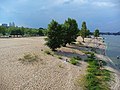 Monastyrskyi Island beach
 -
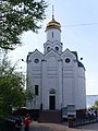 St. Nicholas church on Monastyrskyi Island
 -
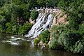 Waterfall on one of the island's steep cliffs


.JPG)
-2.jpg)
Notes
- Ukraine was part of the Soviet Union from 1920 until Ukraine declared its independence from the Soviet Union on 24 August 1991.[6]
References
- ^ Yuri Pakhomenkov (2000). "History of Nadporizhe – Prydniprovye (from the first people to the 17th century)". gorod.dp.ua (in Ukrainian). Retrieved 16 October 2022.
- Dmytro Yavornytskyi National Historical Museum (in Russian). 12 June 2018. Archived from the originalon 12 June 2018. Retrieved 7 July 2019.
- ^ Dmytro Yavornytskyi National Historical Museum(in Ukrainian)
- ^ a b c d e f g h i Maxim Kuvan [in Ukrainian] (c. 2014). "Three Cobzar monuments in the park on bottom-up circles". gorod.dp.ua (in Ukrainian). Retrieved 2 November 2022.
- ^ Ukrayinska Pravda(24 November 2015) (in Ukrainian)
- ISBN 1442610212(page 563/564 & 722/723)
- kp.ua(in Russian). Retrieved 7 July 2019.
- ^ "Памятный крест византийским монахам в Днепропетровске. Парковый комплекс имени Т. Г. Шевченко. – Путеводитель по Днепропетровcкой области". tourdnepr.com (in Russian). Retrieved 7 July 2019.