
Mount Chichantna
| Mount Chichantna | |
|---|---|
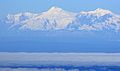
.jpg) Mt. Spurr (L) and Mt. Chichantna (R) Northeast aspect | |
| Highest point | |
| Elevation | 10,893 ft (3,320 m)[1][2] |
| Prominence | 1,443 ft (440 m)[2] |
| Parent peak | Mount Spurr[2] |
| Isolation | 2.41 mi (3.88 km)[2] |
| Coordinates | 61°19′57″N 152°16′23″W / 61.3325000°N 152.2730556°W[3] |
| Geography | |
 Mount Chichantna Location of Mount Chichantna in Alaska | |
| Country | United States |
| State | Alaska |
| Borough | Kenai Peninsula |
| Parent range | Alaska Range Tordrillo Mountains[4] |
| Topo map | USGS Tyonek B-7 |
| Climbing | |
| Easiest route | Expedition climbing |
Mount Chichantna is a 10,893-foot-elevation (3,320-meter) mountain summit in Alaska.
Description
Mount Chichantna is located 80 miles (129 km) west of
Topographic relief is significant as the east face rises nearly 5,900 feet (1,798 meters) in two miles (3.2 km). The mountain is named in association with the Chichantna River which originates from a glacier partly located on this peak.[1] "Chichantna" is a Denaʼina word meaning "from-glacier stream."[5] The mountain's toponym was officially adopted in 1999 by the United States Board on Geographic Names.[3]
Climate
Based on the Köppen climate classification, Mount Chichantna is located in a tundra climate zone with long, cold, snowy winters, and cool summers.[6] Weather systems are forced upwards by the Alaska Range (orographic lift), causing heavy precipitation in the form of snowfall. Winter temperatures can drop below −10 °F with wind chill factors below −20 °F. This climate supports glaciers surrounding the peak including the Capps Glacier to the northeast. The months May through June offer the most favorable weather for viewing or climbing.[7]
See also
- Mountain peaks of Alaska
- Geography of Alaska
Gallery
-
 Mt. Spurr (center) and Mt. Chichantna (upper right) from east
 -
 Mt. Spurr, The Rowel, and Mt. Chichantna from east at Anchorage
 -
 Mt. Chichantna in upper left
 -
 Chichantna (left) and Mt. Nagishlamina (right)
 -
 Chichantna (left of center - see file annotation)
 -
 Chichantna (upper right corner), Spurr centered
.jpg)

.jpg)
.jpg)
.jpg)
.jpg)
References
- ^ a b United States Board on Geographic Names, Decisions on Geographic Names in the United States, Decision List 1999, (1999), page 1.
- ^ a b c d e "Chichantna, Mount - 10,893' AK". listsofjohn.com. Retrieved 2024-01-15.
- ^ a b "Mount Chichantna". Geographic Names Information System. United States Geological Survey, United States Department of the Interior. Retrieved 2024-01-15.
- ^ a b c "Mount Chichantna, Alaska". Peakbagger.com. Retrieved 2024-01-15.
- ISBN 9780806135984, p. 96.
- ISSN 1027-5606.
- ^ Denali FAQ, American Alpine Institute, alpineinstitute.com, Retrieved 2024-01-08.
External links
- Weather forecast: Mount Chichantna
Places adjacent to Mount Chichantna | ||||||||||||||||
|---|---|---|---|---|---|---|---|---|---|---|---|---|---|---|---|---|
| ||||||||||||||||