
Mount Kinesava
| Mount Kinesava | |
|---|---|
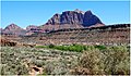
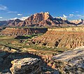
 Mount Kinesava, southwest aspect | |
| Highest point | |
| Elevation | 7,285 ft (2,220 m)[1] |
| Prominence | 685 ft (209 m)[1] |
| Parent peak | The West Temple (7,810 ft)[2] |
| Isolation | 1.06 mi (1.71 km)[2] |
| Coordinates | 37°11′51″N 113°01′50″W / 37.197571°N 113.030571°W[1] |
| Geography | |
 Mount Kinesava Location in Utah  Mount Kinesava Mount Kinesava (the United States) | |
| Country | United States |
| State | class 4 scrambling[2] |
Mount Kinesava is a 7,285-foot (2,220 m) sandstone mountain summit located in Zion National Park, in Washington County of southwest Utah, United States.[3]
Description
Mount Kinesava is located immediately west of
Climate
Spring and fall are the most favorable seasons to visit Mount Kinesava. According to the
Geology

Stratification of sandstone deposits from vast dune fields laid down 175 to 200 million years ago can be seen exposed on the south aspect of the mountain. The uppermost 1,500 feet of this mountain is composed of light-colored Jurassic Navajo Sandstone. Below that layer is deep-red sandstone of the Kayenta Formation, probably best known for its dinosaur tracks, overlying the Springdale Sandstone Member. Continuing lower are the Whitmore Point Member and Dinosaur Canyon Member of the Moenave Formation. Near the base is the Petrified Forest Member of the Chinle Formation, surrounded by landslide deposits.[7]
Gallery
-

-
-

-
-
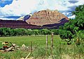
 Mt. Kinesava centered, The Sundial to left
 -

-
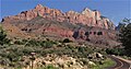 Mt. Kinesava (left), The West Temple (right) from southeast on Hwy 9
 -
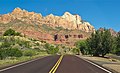 Mt. Kinesava (left), The West Temple straight ahead
 -

.jpg)

.jpg)
.jpg)


See also
References
- ^ a b c d "Mount Kinesava, Utah". Peakbagger.com.
- ^ a b c "Kinesava, Mount - 7,285' UT". listsofjohn.com. Retrieved 2020-09-01.
- ^ a b U.S. Geological Survey Geographic Names Information System: Mount Kinesava
- ^ Who Is “Kinesava”?, Zion Canyon Community, Kinesava.com
- ^ Ron Kay, Ron Kay's Guide to Zion National Park, Countryman Press, 2008, page 94.
- ^ "Zion National Park, Utah, USA - Monthly weather forecast and Climate data". Weather Atlas. Archived from the original on January 27, 2019. Retrieved 31 August 2020.
- ^ Geologic Map of the St. George and the East Part of the Clover Mountains 30' x 60' Quadrangles, Washington and Iron Counties, Utah. Utah Geological Survey, 2010, page 19
External links
- Zion National Park National Park Service
- Weather: Mount Kinesava
- Mt. Kinesava Rock Climbing: mountainproject.com