
Mount Longido
| Mount Longido | |
|---|---|
 | |
| Highest point | |
| Elevation | 2,637 m (8,652 ft)[1] |
| Coordinates | 2°41′S 36°42′E / 2.683°S 36.700°E |
| Geography | |
 Mount Longido Tanzania | |
| Location | Arusha Region, Tanzania |
Mount Longido is a mountain in located in
Longido District of Arusha Region
.
The principal path to the summit starts in the town of
Longido. The climb can be done in one day, but it is also common for climbers to spend one night in a tented camp on the mountain and reach the summit on the second day. Sometimes visitors climb Mount Longido as part of the preparations for the ascent of nearby Mount Kilimanjaro.[1]
See also
- List of Ultras of Africa
- Arusha Region
Gallery
-
 summit
 -
 View of Summit
 -
 Forest guide
 -
-
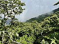
 Flora
Flora -
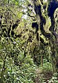 Moss
Moss -
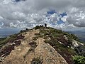 On top of Mt. Longido


References
- ^ ISBN 978-1742207797.
Wikimedia Commons has media related to Mount Longido.