
Mount Kilimanjaro
| Mount Kilimanjaro | |
|---|---|
 Kilimanjaro from Amboseli National Park, Kenya | |
| Highest point | |
| Elevation | 5,895 m (19,341 ft) |
| Prominence | 5,895 m (19,341 ft) Ranked 4th |
| Isolation | 5,510 km (3,420 mi) |
| Listing | Ultra |
| Coordinates | 03°04′33″S 37°21′12″E / 3.07583°S 37.35333°E |
| Geography | |
 Mount Kilimanjaro Kilimanjaro's location in Tanzania  Mount Kilimanjaro Mount Kilimanjaro (Africa) .svg) Mount Kilimanjaro Mount Kilimanjaro (Earth) | |
| Location | Hans Meyer and Ludwig Purtscheller |
Mount Kilimanjaro (
Kilimanjaro's southern and eastern slopes served as the home of the Chagga Kingdoms until their abolition in 1963 by Julius Nyerere. The origin and meaning of the name Kilimanjaro is unknown, but may mean "mountain of greatness" or "unclimbable". Although described in classical sources, German missionary Johannes Rebmann is credited as the first European to report the mountain's existence, in 1848. After several European attempts, Hans Meyer reached Kilimanjaro's highest summit in 1889.
The mountain was incorporated into Kilimanjaro National Park in 1973. As one of the Seven Summits, Kilimanjaro is a major hiking and climbing destination. There are seven established routes to Uhuru Peak, the mountain's highest point. Although not as technically challenging as similar mountains, the prominence of Kilimanjaro poses a serious risk of altitude sickness.
One of
Toponymy
The origin and meaning of the name Kilimanjaro is disputed. Although the
Early Western etymologies used a compound Swahili origin, with kilima translated as "mountain".[5] In 1860, Johann Ludwig Krapf wrote that the Swahilis used the name Kilimanjaro and that it meant either "mountain of greatness" or "mountain of caravans", with a translation of njaro as greatness or jaro as "caravans".[5][6] In 1885, Scottish explorer Joseph Thomson reported "white mountain" as an alternative, with njaro denoting whiteness.[5][7] This Swahili etymological approach is criticized as kilima is a diminutive of mlima (mountain) and actually means "hill". However, mlima may have been misreported as kilima via conflation with the two peaks' names, Kipoo and Kimawenze.[5]
Krapf mentions an 1849 visit with a Wakamba chief that called the mountain Kima jajeu, meaning "mountain of whiteness".[5][8] Another explanation is that jyaro may refer to a god or a deity that guarded the mountain from trespassers.[5]
In the 1880s, the mountain became part of
Geology and geography


Kilimanjaro is a large dormant stratovolcano composed of three distinct volcanic cones: Kibo, the highest; Mawenzi at 5,149 m (16,893 ft);[13] and Shira, the lowest at 4,005 m (13,140 ft).[14] Mawenzi and Shira are extinct, while Kibo is dormant and could erupt again.[15]
Uhuru Peak is the highest summit on Kibo's crater rim. The
A map of the Kibo cone on Mount Kilimanjaro was published by the British government's
Volcanology
The volcanic interior of Kilimanjaro is poorly known because there has not been any significant erosion to expose the
Eruptive activity at the Shira center commenced about 2.5 million years ago, with the last important phase occurring about 1.9 million years ago, just before the northern part of the edifice collapsed.
Both Mawenzi and Kibo began erupting about 1 million years ago.[15] They are separated by the Saddle Plateau at 4,400 m (14,400 ft) elevation.[23]: 3
The youngest dated rocks at Mawenzi are about 448,000 years old.
Kibo is the largest cone on the mountain and is more than 24 km (15 mi) wide at the Saddle Plateau altitude. The last activity here, dated to 150,000–200,000 years ago, created the current Kibo summit crater. Kibo still has gas-emitting fumaroles in its crater.[15][20][22] Kibo is capped by an almost symmetrical cone with escarpments rising 180 to 200 m (590 to 660 ft) on the south side. These escarpments define a 2.5 km-wide (1.6-mile) caldera[24] caused by the collapse of the summit.
Within this caldera is the Inner Cone and within the crater of the Inner Cone is the Reusch Crater, which the Tanganyika government in 1954 named after Gustav Otto Richard Reusch, upon his climbing the mountain for the 25th time (out of 65 attempts during his lifetime).[25][26] The Ash Pit, 350 m (1,150 ft) deep, lies within the Reusch Crater.[27] About 100,000 years ago, part of Kibo's crater rim collapsed, creating the area known as the Western Breach and the Great Barranco.[28]
An almost continuous layer of lava buries most older geological features, except exposed strata within the Great West Notch and the Kibo Barranco. The former exposes intrusions of syenite.[20] Kibo has five main lava formations:[15]
- Phonotephrites and tephriphonolites of the Lava Tower group, on a dyke cropping out at 4,600 m (15,100 ft), dated to 482,000 years ago.
- Tephriphonolite to phonolite lavas "characterized by rhomb mega-phenocrysts of sodic feldspars" of the Rhomb Porphyry group, dated to 460,000–360,000 years ago.
- Aphyric phonolite lavas, "commonly underlain by basal obsidian horizons", of the Lent group, dated to 359,000–337,000 years ago
- Porphyritic tephriphonolite to phonolite lavas of the Caldera Rim group, dated to 274,000–170,000 years ago
- Phonolite lava flows with aegirine phenocrysts, of the Inner Crater group, which represents the last volcanic activity on Kibo
Kibo has more than 250
According to reports gathered in the 19th century from the Maasai, Lake Chala on Kibo's eastern flank was the site of a village that was destroyed by an eruption.[29]
Glaciers

Kibo's ice cap exists because Kilimanjaro is a little-dissected, massive mountain that rises above the snow line. The cap is divergent and at the edges splits into individual glaciers. The central portion of the ice cap is interrupted by the presence of the Kibo crater.[23]: 5 The summit glaciers and ice fields do not display significant horizontal movements because their low thickness precludes major deformation.[30]
Geological evidence shows five successive glacial episodes during the Quaternary period, namely First (500,000 BP), Second (greater than 360,000 years ago to 240,000 BP), Third (150,000 to 120,000 BP), Fourth (also known as "Main") (20,000 to 17,000 BP), and Little (16,000 to 14,000 BP). The Third may have been the most extensive, and the Little appears to be statistically indistinguishable from the Fourth.[31]
A continuous ice cap covering approximately 400 km2 (150 sq mi) down to an elevation of 3,200 m (10,500 ft) covered Kilimanjaro during the
.jpg)
In the late 1880s, the summit of Kibo was completely covered by an ice cap about 20 km2 (7.7 sq mi) in extent with outlet glaciers cascading down the western and southern slopes, and except for the inner cone, the entire caldera was buried. Glacier ice also flowed through the Western Breach.[14][24] The slope glaciers retreated rapidly between 1912 and 1953, in response to a sudden shift in climate at the end of the 19th century that made them "drastically out of equilibrium", and more slowly thereafter. Their continuing demise indicates they are still out of equilibrium in response to a constant change in climate over the past century.[14]
In contrast to the persistent slope glaciers, the glaciers on Kilimanjaro's crater plateau have appeared and disappeared repeatedly during the Holocene epoch, with each cycle lasting a few hundred years.[35]: 1088 It appears that decreasing specific humidity instead of temperature changes has caused the shrinkage of the slope glaciers since the late 19th century. No clear warming trend at the elevation of those glaciers occurred between 1948 and 2005. Although air temperatures at that elevation are always below freezing, solar radiation causes melting on vertical faces. Vertical ice margin walls are a unique characteristic of the summit glaciers and a major place of the shrinkage of the glaciers. They manifest stratifications, calving, and other ice features.[36] "There is no pathway for the plateau glaciers other than to continuously retreat once their vertical margins are exposed to solar radiation."[14] The Kilimanjaro glaciers have been used for deriving ice core records, including two from the southern icefield. Based on this data, this icefield formed between 1,250 and 1,450 years BP.[37]
.jpg)
Almost 85 percent of the ice cover on Kilimanjaro disappeared between October 1912 and June 2011, with coverage decreasing from 11.40 km2 (4.40 sq mi) to <1 km2 (0.39 sq mi)[38][39]: 423 Between 1912 and 1953, there was about a 1.1 percent average annual loss of ice coverage.[34] The average annual loss for 1953 to 1989 was 1.4 percent, while the loss rate for 1989 to 2007 was 2.5 percent.[34] Of the ice cover still present in 2000, almost 40 percent had disappeared by 2011.[39]: 425 Ice climber Will Gadd noticed differences between his 2014 and 2020 climbs.[40] The glaciers are thinning in addition to losing areal coverage,[34] and do not have active accumulation zones; retreat occurs on all glacier surfaces. Loss of glacier mass is caused by both melting and sublimation.[30] While the current shrinking and thinning of Kilimanjaro's ice fields appear to be unique within its almost twelve-millennium history, it is contemporaneous with widespread glacier retreat in mid-to-low latitudes across the globe.[34] In 2013, it was estimated that, at the current rate of global warming, most of the ice on Kilimanjaro will disappear by 2040, and "it is highly unlikely that any ice body will remain after 2060".[39]: 430
The Furtwangler Glacier on Kilimanjaro is a remnant of the ice cap that once covered the mountain. This has retreated dramatically over the last century with over 80 percent glacial retreat. The glacier is named after Walter Furtwangler, who along with Ziegfried Koenig, was the fourth to ascend to the summit of Kilimanjaro in 1912.[41]
A complete disappearance of the ice would be of only "negligible importance" to the water budget of the area around the mountain. The forests of Kilimanjaro, far below the ice fields, "are [the] essential water reservoirs for the local and regional populations".[42]
Drainage
Kilimanjaro is drained by a network of rivers and streams, especially on the wetter and more heavily eroded southern side and primarily above 1,200 m (3,900 ft). Below that altitude, increased evaporation and human water usage reduce the water flows. The Lumi and Pangani rivers drain Kilimanjaro on the eastern and southern sides, respectively.[43]
IUGS geological heritage site
In respect of it being 'the highest stratovolcano of the East African Rift that maintains a glacier on its summit', the International Union of Geological Sciences (IUGS) included 'The Pleistocene Kilimanjaro volcano' in its assemblage of 100 'geological heritage sites' around the world in a listing published in October 2022. The organization defines an IUGS Geological Heritage Site as 'a key place with geological elements and/or processes of international scientific relevance, used as a reference, and/or with a substantial contribution to the development of geological sciences through history.'[44]
Human history
Chagga states
Kilimanjaro is attested to in numerous stories by the people who live in East Africa. The
Another Chagga legend tells of ivory-filled graves of elephants on the mountain, and of a cow named Rayli that produces miraculous fat from her tail glands. If a man tries to steal such a gland but is too slow in his moves, Rayli will blast a powerful snort and blow the thief down onto the plain.[46]
Early records
The mountain may have been known to non-Africans since antiquity. Sailors' reports recorded by Ptolemy mention a "moon mountain" and a spring lake of the Nile, which may indicate Kilimanjaro, although available historical information does not allow differentiation among others in East Africa like Mount Kenya, the mountains of Ethiopia, the Virunga Mountains, the Rwenzori Mountains, and Kilimanjaro. Before Ptolemy, Aeschylus and Herodotus referred to "Egypt nurtured by the snows" and to a spring between two mountains, respectively. One of these mentions two tall mountains in the coastal regions with a valley with traces of fire between them. Martín Fernández de Enciso, a Spanish traveler to Mombasa who obtained information about the interior from native caravans, said in his Summa de Geografía (1519) that west of Mombasa "stands the Ethiopian Mount Olympus, which is exceedingly high, and beyond it are the Mountains of the Moon, in which are the sources of the Nile".[29][47]: 1–5 [48]: 114
European exploration

The German missionaries Johannes Rebmann of Mombasa and Johann Krapf were the first Europeans known to have attempted to reach the mountain. According to English geographer Halford Mackinder and English explorer Harry Johnston, Rebmann in 1848 was the first European to report the existence of Kilimanjaro.[49][50] Hans Meyer has claimed that Rebmann first arrived in Africa in 1846 and quotes Rebmann's diary entry of 11 May 1848 as saying,
This morning, at 10 o'clock, we obtained a clearer view of the mountains of Jagga, the summit of one of which was covered by what looked like a beautiful white cloud. When I inquired as to the dazzling whiteness, the guide merely called it 'cold' and at once I knew it could be neither more nor less than snow.... Immediately I understood how to interpret the marvelous tales Dr. Krapf and I had heard at the coast, of a vast mountain of gold and silver in the far interior, the approach to which was guarded by evil spirits.[47]: 6
In August 1861, the Prussian officer Baron Karl Klaus von der Decken accompanied by English geologist Richard Thornton[51] attempted to climb Kibo but "got no farther than 2,500 m (8,200 ft) owing to the inclemency of the weather".[47]: 9 [52] In December 1862, von der Decken tried a second time together with Otto Kersten, reaching a height of 4,300 m (14,000 ft).[53]
.jpg)
In August 1871, missionary Charles New became the "first European to reach the equatorial snows" on Kilimanjaro at an elevation of slightly more than 4,000 m (13,000 ft).
In 1889, Meyer returned to Kilimanjaro with the Austrian mountaineer Ludwig Purtscheller for a third attempt.[55]: 82 This attempt was based on the establishment of several campsites with food supplies so that multiple attempts at the top could be made without having to descend too far.[55]: 82 Meyer and Purtscheller pushed to near the crater rim on 3 October but turned back exhausted from hacking footsteps in the icy slope.[55]: 82 Three days later, they reached the highest summit, on the southern rim of the crater.[55]: 82 They were the first to confirm that Kibo has a crater.[55]: 82 After descending to the saddle between Kibo and Mawenzi, Meyer and Purtscheller attempted to climb the more technically challenging Mawenzi but could only reach the top of Klute Peak, a subsidiary peak, before retreating due to illness.[55]: 84 On 18 October, they reascended Kibo to enter and study the crater, cresting the rim at Hans Meyers Notch.[55]: 84 In total, Meyer and Purtscheller spent 16 days above 4,600 m (15,000 ft) during their expedition.[55]: 84 They were accompanied in their high camps by Mwini Amani of Pangani, who cooked and supplied the sites with water and firewood.[47]: 135–186
First women climbers
In 1909, London-born Gertrude Benham attempted to reach the summit of Mount Kilimanjaro. After her porters abandoned the expedition upon discovering the skeletons of previous climbers, Benham continued alone and reached the edge of Kibo Crater, later named Gilman’s Point. Adverse weather conditions, including heavy snow and fog, made navigation difficult, leading her to turn back.[56] The first woman to successfully reach the summit of Kilimanjaro was Sheila MacDonald, who completed the ascent on September 30, 1927, at the age of 22.[57]
Modern
"We will light a candle on top of Mount Kilimanjaro which will shine beyond our borders, giving hope where there is despair, love where there is hate, and dignity where before there was only humiliation."
The first ascent of the highest summit of Mawenzi was made on 29 July 1912, by the German climbers Eduard Hans Oehler and Fritz Klute, who named it Hans Meyer Peak. Oehler and Klute went on to make the third-ever ascent of Kibo, via the Drygalski Glacier, and descended via the Western Breach.[55]: 85 The mountain lent its name to the 1914 Battle of Kilimanjaro during World War I.
In 1989, the organizing committee of the 100-year celebration of the first ascent decided to award posthumous certificates to the African porter-guides who had accompanied Meyer and Purtscheller.[59] One person in pictures or documents of the 1889 expedition was thought to match a living inhabitant of Marangu, Yohani Kinyala Lauwo.[59] Lauwo did not know his own age,[59] nor remember Meyer or Purtscheller. He did recall joining a Kilimanjaro expedition involving a Dutch doctor who lived near the mountain, and that he did not wear shoes during the climb.[59] Lauwo claimed that he had climbed the mountain three times before the beginning of World War I.[59] The committee concluded that he had been a member of Meyer's team and therefore must have been born around 1871.[59] Lauwo died on 10 May 1996, 107 years after the first ascent. It is sometimes suggested that he was a co-first-ascendant of Kilimanjaro.[60]
Fauna and flora
Animals

Large animals are rare on Kilimanjaro and are more frequent in the forests and lower parts of the mountain.
Vegetation

Natural forests cover about 1,000 km2 (250,000 acres) on Kilimanjaro.
The lower northern and western slopes are dominated by Acacia savanna, while most of the wooded grassland of the lower southern and eastern slopes have been destroyed for cultivation.[68]
Records from the Maundi crater at 2,780 m (9,120 ft) indicate that the vegetation of Kilimanjaro has varied over time. Forest vegetation retreated during the Last Glacial Maximum and the ericaceous vegetation belt lowered by 1,500 m (4,900 ft) between 42,000 and 30,000 years ago because of the drier and colder conditions.[65]
The Tussock Grassland is an area on the slopes of Mount Kilimanjaro that contains many unique species of vegetation, such as the
Conservation
Since 1973, Mount Kilimanjaro has been designated as a national park, prohibiting human activities within its boundaries to preserve its ecosystem.[69] The government has also implemented a ban on tree harvesting to prevent environmental degradation and protect the park's biodiversity.[70]
Climate

.jpg)

The climate of Kilimanjaro is influenced by the height of the mountain, which allows the simultaneous influence of the equatorial
Kilimanjaro has two distinct rainy seasons, one from March to May and another around November. The northern slopes receive much less rainfall than the southern ones.[64] The lower southern slope receives 800 to 900 mm (31 to 35 in) annually, rising to 1,500 to 2,000 mm (59 to 79 in) at 1,500 m (4,900 ft) altitude and peaking "partly over" 3,000 mm (120 in) in the forest belt at 2,000 to 2,300 m (6,600 to 7,500 ft). In the alpine zone, annual precipitation decreases to 200 mm (7.9 in).[66]: 18
The average temperature in the summit area is approximately −7 °C (19 °F). Nighttime surface temperatures on the Northern Ice Field (NIF) fall on average to −9 °C (16 °F), with an average daytime high of −4 °C (25 °F). During nights of extreme radiational cooling, the NIF can cool to as low as −15 to −27 °C (5 to −17 °F).[36]: 674
Snowfall can occur at any time of year but is mostly associated with northern Tanzania's two rainy seasons.[36]: 673 Precipitation in the summit area occurs principally as snow and graupel of 250 to 500 mm (9.8 to 19.7 in) per year and ablates within days or years.[30]
Climatic zones
- Bushland / Lower Slope:, 800 to 1,800 m (2,600 to 5,900 ft)
- Rainforest: 1,800 to 2,800 m (5,900 to 9,200 ft)
- Heather / Moorland: 2,800 to 4,000 m (9,200 to 13,100 ft)
- Alpine Desert: 4,000 to 5,000 m (13,000 to 16,000 ft)
- Arctic: 5,000 to 5,895 m (16,404 to 19,341 ft).[71]
Tourism industry
Kilimanjaro National Park generated US$51 million in revenue in 2013,[72]: 285 the second-most of any Tanzanian national park.[73]: 258 The Tanzania National Parks Authority reported that the park recorded 57,456 tourists during the 2011–12 budget year, of whom 16,425 hiked the mountain; the park's General Management Plan specifies an annual capacity of 28,470.[74] The mountain hikers generated irregular and seasonal jobs for about 11,000 guides, porters, and cooks in 2007.[75] Concerns have been raised about the poor working conditions and inadequate wages of these workers.[72]: 287–291 [73]: 259 [75] Due to Kilimanjaro National Park's popularity as a destination, the Tanzanian government has invested in road infrastructure to improve accessibility. In Tanzania, Kilimanjaro International Airport also serves as an important transportation hub.[76]
There are seven official trekking routes by which to ascend and descend Kilimanjaro: Lemosho, Lemosho Western-Breach, Machame, Marangu, Mweka, Rongai, Shira, and Umbwe.[77] The Machame route can be completed in six or seven days,[78] Lemosho in six to eight, and the Northern Circuit routes in seven or more days.[79] The Lemosho Route can also be continued via the Western-Breach, submitting via the western side of the mountain. The Western Breach is more secluded and avoids the 6-hour midnight ascent to the summit (like other routes). The Rongai is the easiest of the camping routes.[80] The Marangu is also relatively easy, if frequently busy; accommodation is in shared huts.[81] The Lemosho Western-Breach Route commences on the western side of Kilimanjaro at Lemosho and continues to the summit via the Western-Breach Route.[71][82]

Mawenzi technical climbing
Technical climbing routes are available on the Mawenzi cone of Mount Kilimanjaro.[83] Unlike the traditional routes to Uhuru Peak on Kibo, which are open to the general public, climbing Mawenzi requires a special permit from the Tanzania National Parks Authority. These permits are issued exclusively to experienced climbers with appropriate equipment. Climbing on Mawenzi is limited to a maximum of two climbers at a time and is restricted to daytime hours.[84]
Climbing records

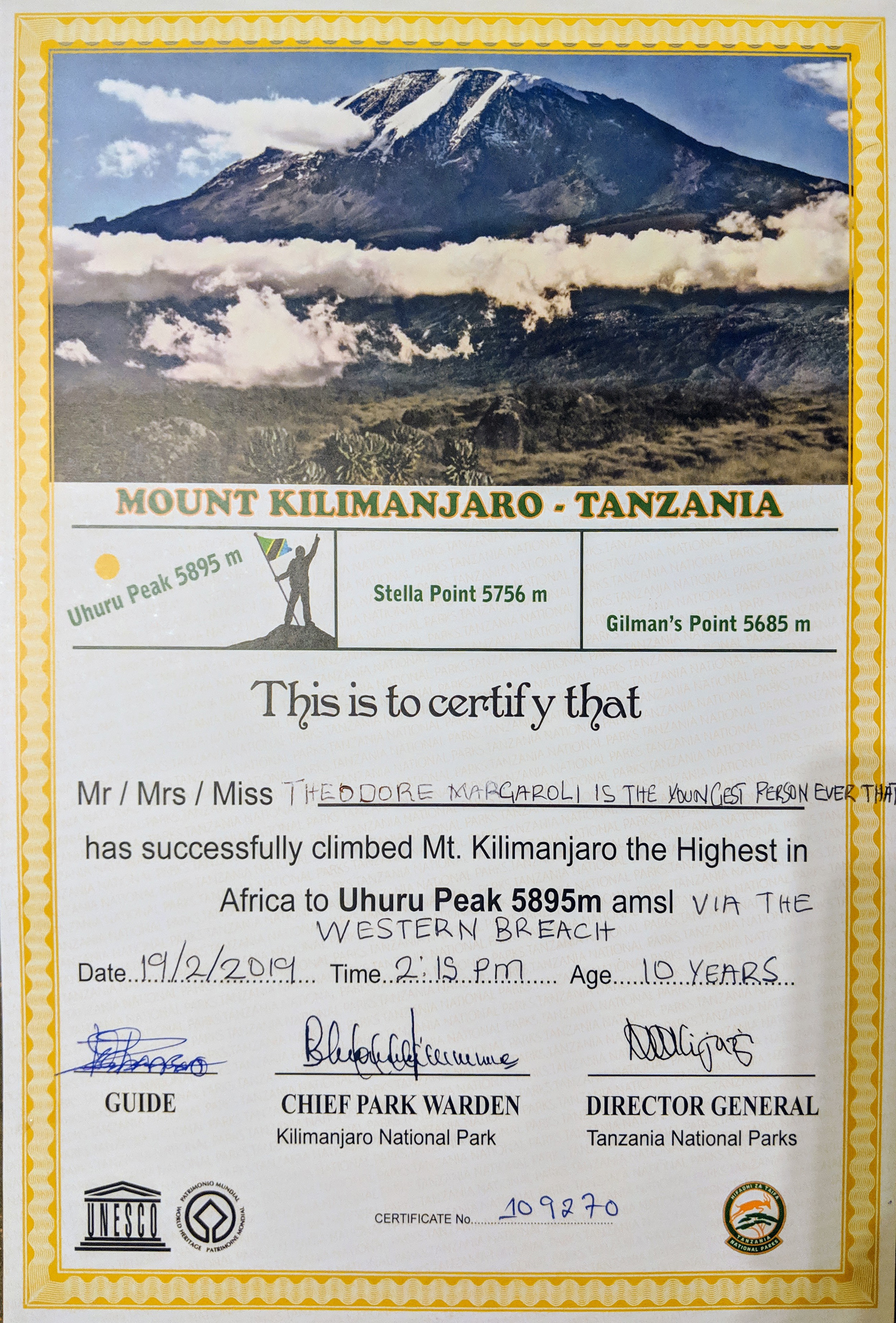
The oldest person to climb Mount Kilimanjaro is Anne Lorimor, aged 89 years and 37 days, who reached Uhuru Peak at 3:14 p.m. local time on 18 July 2019.[85][86] The oldest man to summit is American Fred Dishelhorst, who reached the top on 19 July 2017 at the age of 88 years old.[87] The second oldest man to summit the mountain is the American Robert Wheeler, who was 85 years and 201 days when he summited on 2 October 2014.[88] Maxwell J. Ojerholm of Massachusetts, USA, reached Uhuru Peak, the true summit, unassisted, at the age of ten years, on July 4, 2009, taking the difficult Machame Route. Colin M. Barker of Missouri, USA, later completed the same route at the age of ten on December 22, 2020. Theodore Margaroli from London, age 10, reached the summit unassisted by the Western Breach, the hardest but most scenic route, in 2019.[88][89] Despite an age limit of 10 years for a climbing permit, Keats Boyd from Los Angeles reached the summit on 21 January 2008 at the age of 7.[88] This record was equaled by Montannah Kenney from Texas in March 2018 and again in July 2018 by Coaltan Tanner from New Mexico.[88][90][91][92] The fastest ascent and the fastest round trip have been recorded by the Swiss-Ecuadorian mountain guide
The female round trip record is held by Fernanda Maciel from Brazil in a time of 10 hours and 6 minutes.[93] Her ascent time of 7:08 was broken on 23 February 2018 by the Danish ultramarathon runner Kristina Schou Madsen with a time of 6:52:54 from Mweka Gate.[93][97]
Several climbs by disabled people have drawn attention. Wheelchair user Bernard Goosen from South Africa scaled Kilimanjaro in six days in 2007. In 2012, Kyle Maynard who has no forearms or lower legs, crawled unassisted to the summit of Mount Kilimanjaro.[88]
On February 9, 2015, Red Bull athlete Valerii Rozov performed the first wing-suit BASE jump from the summit of Mount Kilimanjaro. He flew approximately 3 kilometres before landing on the southern slope.[98]
In 2020, a team featuring two double above-knee amputees, Hari Budha Magar and Justin Oliver Davis, summited Kilimanjaro. It took them six days to cover the 56 km (35 mi) distance to the summit.[99]
Safety
The climb is not technically as challenging as the Himalayas or Andes, but the high elevation, low temperature, and occasional high winds can make Kilimanjaro a difficult trek. Acclimatization is required, and even experienced and physically fit trekkers may suffer some degree of altitude sickness.[100][101] A study of people attempting to reach the summit of Kilimanjaro in July and August 2005 found that 61.3 percent succeeded and 77 percent experienced acute mountain sickness (AMS).[102] A retrospective study of 917 persons who attempted to reach the summit via the Lemosho or Machame routes found that 70.4 percent experienced AMS, defined in this study to be headache, nausea, diarrhea, vomiting, or loss of appetite.[103]
Kilimanjaro's summit is well above the altitude at which life-threatening
Falls on steep portions of the mountain and rock slides have killed trekkers. For this reason, the route via the Arrow Glacier was closed for several years, reopening in December 2007. Now again it officially closed as of January 20, 2024. Due to strong El Niño, the Western Breach has washed down the mountain. This huge runoff has carved new ravines on the slopes and seems to be dislodging the sediment that cements the rock together, disrupting the rock stability. At the route's base, rain water has opened new drainages and there is an active, flowing river through the Arrow Glacier Camp where there has been no water at all for decades.[108][109] The improper disposal of human waste on the mountain environment has created a health hazard, necessitating the boiling of all water.[110]
According to the Kilimanjaro Christian Medical Centre in Moshi, 25 people died from January 1996 to October 2003 while climbing the mountain. Seventeen were female and eight were male, ranging in age from 29 to 74. Fourteen died from advanced high altitude illness, including one with
In literature and film
Kilimanjaro is a snow-covered mountain 19,710 feet high, and is said to be the highest mountain in Africa. Its western summit is called the Masai 'Ngaje Ngai', the House of God. Close to the western summit there is a dried and frozen carcas of a leopard. No one has explained what the leopard was seeking at that altitude.
Journalist Tom Bissell noted that Kilimanjaro is "perhaps the world's most literary mountain".[113] The mountain is prominently featured in Ernest Hemingway's 1936 short story The Snows of Kilimanjaro, which was adapted into a 1952 film starring Gregory Peck.[114] Dave Eggers wrote about his ascent in the short story Up the Mountain Coming Down Slowly.[113] The ascent of Kilimanjaro is depicted in Andrei Gusev's 2020 novel Once in Malindi (in the 17th chapter).[115][116][117] Writer Douglas Adams climbed the mountain in a rubber rhinoceros suit to raise money for African rhino conservation efforts.[113][118]
Kilimanjaro was featured in
References
Citations
- ^ a b Sharaf, Yasir (26 April 2022). "8 Common Mistakes I Wish I Knew Before Climbing Mount Kilimanjaro As A Beginner | How To Climb Mount Kilimanjaro?". XPATS International. Archived from the original on 25 June 2024. Retrieved 6 August 2022.
- ^ ISBN 0-906227-66-6. Archived from the originalon 17 July 2015.
- ^ "Kilimanjaro, Mount". Oxford Dictionaries UK English Dictionary. Oxford University Press. Archived from the original on 16 July 2015. "Kilimanjaro, Mount". Lexico. Archived from the original on 9 July 2015. Retrieved 25 August 2014.
- ^ [citation needed]
- ^ a b c d e f g Hutchinson 1965, p. 65.
- ^ Krapf & Ravenstein 1860, p. 255.
- ^ Thomson 1887.
- ^ Krapf & Ravenstein 1860, p. 544.
- ^ Briggs, Philip (1996). Guide to Tanzania, 2nd edition. Bradt Guides.
- ^ Demhardt, I. J. German Contributions to the Cartography of South West and East Africa from Mid-19th Century to World War I (PDF). University of Technology Darmstadt. Archived (PDF) from the original on 17 July 2015. Retrieved 16 July 2015.
- ^ Dangar, D. F. O. (1965). "Dangar Alpine Notes" (PDF). The Alpine Journal. 70 (310–311): 328. Archived (PDF) from the original on 3 December 2013. Retrieved 26 November 2012.
- JSTOR 1788958.
- ^ Sharaf, Yasir (24 March 2016). "Mount Kilimanjaro Volcanic Cones: Shira, Kibo And Mawenzi Peaks". XPATS International. Archived from the original on 5 November 2021. Retrieved 25 September 2021.
- ^ S2CID 14421037.
- ^ (PDF) from the original on 15 January 2019. Retrieved 8 January 2019.
- ^ "Kilimanjaro National Park". World Heritage List. UNESCO World Heritage Centre. Archived from the original on 19 April 2012. Retrieved 16 July 2015.
- ^ a b Pascal Sirguey, Nicolas J. Cullen and Jorge Filipe Dos Santos. "The New Digital Orthometric Elevation Model of Kilimanjaro" (PDF). CEUR Workshop Proceedings. Archived (PDF) from the original on 4 March 2016. Retrieved 16 July 2015.
- ^ Pascal SRIGUEY & Nicolas J. CULLEN (2014). "A Century of Photogrammetry on Kilimanjaro" (PDF). Engaging the Challenges – Enhancing the Relevance. FIG Congress 2014. Kuala Lumpur, Malaysia. Archived (PDF) from the original on 21 July 2015. Retrieved 16 July 2015.
- ^ ISBN 978-1-84965-622-1. Archivedfrom the original on 23 February 2017. Retrieved 4 October 2016.
- ^ S2CID 128393681.
- ^ "Kilimanjaro Geology". Tranquil Kilimajaro. Archived from the original on 25 June 2024. Retrieved 25 February 2024.
- ^ ISBN 978-1-86239-267-0. Archivedfrom the original on 23 February 2017. Retrieved 4 October 2016.
- ^ JSTOR 1780513.
- ^ a b c Young, James A. T. "Glaciers of the Middle East and Africa" (PDF). U.S. Geological Professional Survey. U.S. Department of the Interior. pp. G61, G58, G59 G62. Archived (PDF) from the original on 28 July 2012. Retrieved 16 August 2012.
- ^ "Gustav Otto Richard Reusch". Biographies. The Center for Volga German Studies at Concordia University. Archived from the original on 24 October 2015. Retrieved 16 July 2015.
- ISBN 978-1-60509-527-1. Retrieved 4 October 2016.
- ^ "Kilimanjaro". Volcano World. Oregon State University. 25 April 2011. Archived from the original on 18 July 2015. Retrieved 16 July 2015.
- ISBN 978-1-84965-622-1. Archivedfrom the original on 23 February 2017. Retrieved 4 October 2016.
- ^ from the original on 23 January 2018. Retrieved 5 September 2017 – via Springer Link.
- ^ .
- S2CID 130605599.
- S2CID 32880316. Archived from the original(PDF) on 5 February 2012. Retrieved 16 August 2012.
- Bibcode:2015EGUGA..17.5091U.
- ^ PMID 19884500.
- S2CID 16945088.
- ^ ISBN 978-90-481-2641-5. Archivedfrom the original on 23 February 2017. Retrieved 4 October 2016.
- ISBN 978-0-444-52747-9.
- .
- ^ ISSN 1994-0424.
- ^ Zeinab, Noura Abou (15 October 2020). "'Big pieces' of Kilimanjaro 'missing' due to climate crisis, says ice climber Will Gadd". CNN. Archived from the original on 5 October 2024. Retrieved 15 October 2020.
- ^ Nkonge, Peninah (15 October 2022). "'Hiking Adventures In East Africa's Tallest Mountains". Sunrise Africa Tours and Safaris. Archived from the original on 25 June 2024. Retrieved 15 October 2022.
- (PDF) from the original on 15 October 2014. Retrieved 9 October 2014.
- ISBN 978-2-8317-0070-0. Archivedfrom the original on 23 February 2017. Retrieved 4 October 2016.
- ^ "The First 100 IUGS Geological Heritage Sites" (PDF). IUGS International Commission on Geoheritage. IUGS. Archived (PDF) from the original on 27 October 2022. Retrieved 13 November 2022.
- ^ "THE GEOGRAPHY PEOPLE AND MYTHOLOGY OF AFRICA'S HIGHEST PEAK". www.secretcompass.com. 2 January 2018. Archived from the original on 5 November 2021. Retrieved 6 February 2021.
- ISBN 978-1-136-24940-2. Archivedfrom the original on 23 February 2017. Retrieved 4 October 2016.
- ^ from the original on 23 February 2017. Retrieved 4 October 2016.
- ISBN 978-0-89886-604-9. Retrieved 4 October 2016.
- from the original on 25 June 2024. Retrieved 5 July 2019.
- ^ ""Kilimanjaro", authored by Sir. H. H. Johnston, in The Twentieth Century, published by Nineteenth Century and After, printed by Spottswoode, Ballantine & Co. Ltd., London, June 1916, volume 79, page 879". 1916. Archived from the original on 19 September 2015. Retrieved 28 July 2015.
- ^ "Mr Thornton, I presume?: Everyone has heard of Livingstone, but the name of Richard Thornton, Livingstone's geologist, has been completely forgotten. Richard Boak tells his sad story". www.geolsoc.org.uk. August 2011. Archived from the original on 24 February 2016. Retrieved 6 February 2021.
- ISBN 978-1-136-24940-2. Archivedfrom the original on 23 February 2017. Retrieved 4 November 2014.
- ^ "Baron Carl Claus von der Decken – 1833–1865 – Collectors in East Africa – 31". Conchological Society of Great Britain and Ireland. Archived from the original on 16 July 2015. Retrieved 16 July 2015.
- ^ Ludwig Ritter von Höhnel (1894). Discovery of Lakes Rudolf and Stefanie: A Narrative of Count Samuel Teleki's Exploring & Hunting Expedition in Eastern Equatorial Africa in 1887 & 1888. Longmans, Green. p. 195.
- ^ ISBN 978-1-84965-071-7. Archivedfrom the original on 24 February 2017. Retrieved 4 October 2016.
- ^ "The amazing story of the first woman on Kilimanjaro". Altezza Travel. Retrieved 14 February 2025.
- ISSN 0261-3077. Retrieved 14 February 2025.
- ^ Bernbaum 2006, p. 308.
- ^ a b c d e f "Meyer And Purtscheller Were Not Alone". Tanzanian Affairs. 1 January 1990. Archived from the original on 17 July 2015. Retrieved 16 July 2015.
- ^ "The Old Man of Mt. Kilimanjaro". The Honeyguide: Summer 2000. Another Land. Archived from the original on 25 November 2014. Retrieved 16 July 2015.
- ISBN 978-0-89886-604-9. Retrieved 4 October 2016.
- ^ "Climbing Mount Kilimanjaro". IUCN Red List of Threatened Species. Ascend Tanzania. Archived from the original on 3 January 2019. Retrieved 26 October 2019.
- ^ "Kinyongia tavetana (STEINDACHNER, 1891)". The Reptile Database. Zoological Museum Hamburg. Archived from the original on 19 September 2015. Retrieved 15 August 2015.
- ^ S2CID 21864541.
- ^ .
- ^ S2CID 25001477.
- ISBN 978-1-139-49455-7. Archivedfrom the original on 24 February 2017. Retrieved 4 October 2016.
- ^ Grimshaw, Cordeiro & Foley 1995, p. 106.
- ^ Tanzania National Parks Authority. "Kilimanjaro National Park Celebrating the Golden Anniversary in Biodiversity Conservation and Tourism" (PDF). Tanzania National Parks Authority.
- ISBN 978-0-8108-3244-2.
- ^ a b "Information about Mt Kilimanjaro". Kiliwarrior Expeditions – Climb Kilimanjaro and become a Kiliwarrior!. Archived from the original on 3 January 2019. Retrieved 3 January 2019.
- ^ ISBN 978-1-317-66874-9. Archivedfrom the original on 23 February 2017. Retrieved 4 October 2016.
- ^ ISBN 978-1-4648-0197-6. Archivedfrom the original on 19 September 2015. Retrieved 31 July 2015.
- ^ "The official site of the Tanzania National Parks – Latest news". 16 March 2014. Archived from the original on 24 September 2015. Retrieved 23 October 2017.
- ^ a b ""Making success work for the poor: Package tourism in Northern Tanzania", Overseas Development Institute, authored by Jonathan Mitchell, Jodie Keane, and Jenny Laidlaw, 9 January 2008, accessed 31 July 2015" (PDF). odi.org. Archived (PDF) from the original on 4 March 2016. Retrieved 23 October 2017.
- ^ Ihucha, Adam (28 November 2015). "Kilimanjaro airport upgrade to double its capacity". The EastAfrican. Nairobi. Archived from the original on 17 April 2022. Retrieved 5 April 2020.
- ^ "Mt. Kilimanjaro Routes: The Advantages and Disadvantage of All Mount Kilimanjaro Climbing Routes". Mount Kilimanjaro Guide. Archived from the original on 1 July 2015. Retrieved 16 July 2015.
- ^ "Climbing Mount Kilimanjaro on the Machame Route". Mount Kilimanjaro Guide. Archived from the original on 23 June 2017. Retrieved 16 July 2015.
- ^ "Climbing Mount Kilimanjaro on the Lemosho Route". Climbing Kilimanjaro. Archived from the original on 26 June 2017. Retrieved 10 July 2015.
- ^ "Climbing Mount Kilimanjaro on the Rongai Route". Mount Kilimanjaro Guide. Archived from the original on 1 July 2015. Retrieved 16 July 2015.
- ^ "Marangu Route". Kilimanjaro Routes. Archived from the original on 16 August 2015. Retrieved 16 July 2015.
- ^ "Kiliwarrior Expeditions – Climb Kilimanjaro and become a Kiliwarrior!". Kiliwarrior Expeditions – Climb Kilimanjaro and become a Kiliwarrior!. Archived from the original on 3 January 2019. Retrieved 3 January 2019.
- ^ "Mawenzi Peak — A Volcano in the Kilimanjaro Massif". Altezza Travel. Retrieved 8 January 2025.
- ^ "Mawenzi technical climbing guidelines" (PDF). Tanzania National Parks Authority. Retrieved 8 January 2025.
- ^ "Oldest person to climb Mount Kilimanjaro". guinnessworldrecords.com. Archived from the original on 5 October 2024. Retrieved 3 December 2019.
- ^ "Anne Lorimor breaks record twice on Mount Kilimanjaro". ultimatekilimanjaro.com. 26 July 2019. Archived from the original on 5 October 2024. Retrieved 12 December 2021.
- ^ "Oldest man climbs Kilimanjaro". peakplanet.com. 23 July 2017. Archived from the original on 5 October 2024. Retrieved 12 December 2021.
- ^ a b c d e f "Amazing Kilimanjaro Records". Mount Kilimanjaro Facts. Climb Kilimanjaro Guide. Archived from the original on 17 July 2015. Retrieved 16 July 2015.
- ^ "Youngest person to climb Mount Kilimanjaro via the Western Breach route". Archived from the original on 5 October 2024.
- ^ "Girl Who Wanted to 'Be Closer to Her Dad' Becomes Youngest Female to Hike Mount Kilimanjaro". Good News Network. 10 April 2018. Archived from the original on 12 April 2018. Retrieved 11 April 2018.
- ^ "The youngest Person to Climb Mount Kilimanjaro | Seven Brave Children". 19 October 2022. Archived from the original on 5 October 2024.
- ^ "Albuquerque boy becomes youngest ever to summit Mt. Kilimanjaro". 1 November 2018. Archived from the original on 2 December 2022.
- ^ a b c Route: Kilimanjaro Archived 9 December 2018 at the Wayback Machine at fastest known time.com
- ^ Matt Hart, Where in the World Did Karl Egloff Come From? Archived 1 April 2015 at the Wayback Machine, Outside 5, Mar 2015
- ^ Swiss Sets New Kilimanjaro Fastest Ascent And Descent Record Archived 19 July 2018 at the Wayback Machine at climbkilimanjaroguide.com
- ^ "Kilimanjaro records". Background information on Kilimanjaro. Climb Mount Kilimanjaro Ltd. Archived from the original on 16 July 2015. Retrieved 16 July 2015.
- ^ Sean McCoy, Woman Sets Speed Record Up Kilimanjaro Archived 9 December 2018 at the Wayback Machine at gearjunkie.com
- ^ "Trip Report: the First BASE Jump from Kilimanjaro". Altezza Travel. Retrieved 16 December 2024.
- ^ "Two double amputees, Hari and Justin, successfully climb Mt Kilimanjaro". www.southasiatime.com. Archived from the original on 25 June 2024. Retrieved 25 October 2021.
- ^ Muza, SR, Fulco, CS, Cymerman, A (2004). Altitude Acclimatization Guide. US Army Research Inst. Of Environmental Medicine Thermal and Mountain Medicine Division Technical Report (Report). Archived from the original on 14 February 2016. Retrieved 16 July 2015.
- ^ Stoppelenburg, R. "Prepare yourself for the Kilimanjaro climb". Archived from the original on 19 March 2009. Retrieved 27 February 2009.
- (PDF) from the original on 8 December 2015. Retrieved 28 July 2015.
- PMID 25329946.
- ^ Cymerman, A, Rock, PB. Medical Problems in High Mountain Environments. A Handbook for Medical Officers (Report). Vol. USARIEM-TN94-2. US Army Research Inst. of Environmental Medicine Thermal and Mountain Medicine Division Technical Report. Archived from the original on 7 February 2012. Retrieved 5 March 2009.
- (PDF) from the original on 8 December 2015. Retrieved 28 July 2015.
- PMID 23270446.
- ^ "Machame Route". Kopa Tours. 17 December 2019. Archived from the original on 25 June 2024. Retrieved 9 April 2021.
- ^ "Western Breach Route". Western Breach Route Kilimanjaro. Climbing Kilimanjaro. Archived from the original on 25 June 2024. Retrieved 26 October 2019.
- ^ "Lava Tower en route to Barranco Camp". Africa Travel. About.com. Archived from the original on 27 September 2011. Retrieved 23 March 2011.
- S2CID 113843846.
- ^ Markus Hauser; Andreas Mueller; Britta Swai; Sendui Ole Nguyaine (2004). "Deaths Due to High Altitude Illness Among Tourists Climbing Mt Kilimanjaro". Proceedings of the 2004 South African Travel Medicine Society. Archived from the original on 17 November 2015. Retrieved 8 November 2015.
- ^ Stephens 1960, p. 85.
- ^ a b c Bissell, Tom (28 October 2007). "Up the Mountain Slowly, Very Slowly". The New York Times. Archived from the original on 5 October 2024. Retrieved 25 June 2024.
- ^ Crowther, Bosley (19 September 1952). "The Screen in Review; 'Snow of Kiliminjaro,' Based on Hemingway's Story, Is New Feature at Rivoli". The New York Times. Archived from the original on 5 October 2024. Retrieved 25 June 2024.
- ^ Review of "Once in Malindi" on the site of public fund "Union of writers of Moscow", 2021 (in Russian)
- ^ "Once in Malindi" Archived 2020-10-16 at the Wayback Machine — on Proza.ru, 2020 (in Russian)
- ^ Андрей Гусев “Однажды в Малинди”, 2020. Archived 2020-11-04 at the Wayback Machine
- ^ "Up Kilimanjaro with the Adams Family". BBC. 24 September 2014. Archived from the original on 25 June 2024. Retrieved 25 June 2024.
- ^ Hann, Michael (13 June 2018). "The strange appeal of Toto's Africa – and why it's cover-proof". Financial Times. Archived from the original on 7 December 2022. Retrieved 12 October 2024.
- ^ "Kilimanjaro: To The Roof Of Africa". IMAX. 20 April 2023. Archived from the original on 25 June 2024. Retrieved 25 June 2024.
Works cited
Academic articles
- Hutchinson, J. A. (1965). "The Meaning of Kilimanjaro". Department of Language and Linguistics. Dar Es Salaam: University College. Archived from the original on 6 October 2007.
- Stephens, Robert O. (March 1960). "Hemingway's Riddle of Kilimanjaro: Idea and Image". American Literature. 32 (1): 84–87. JSTOR 2922805.
- Bernbaum, Edwin (November 2006). "Sacred Mountains: Themes and Teachings". Mountain Research and Development. 26 (4). International Mountain Society: 304–309. from the original on 15 August 2020. Retrieved 23 October 2024.
- Grimshaw, J. M.; Cordeiro, N.J.; Foley, C.A.H (July 1995). "The Mammals of Kilimanjaro". Journal of East African Natural History. 84 (2): 105–139. .
- Davies, Andrew J.; Kalson, Nicholas S.; Stokes, Suzy; Earl, Mark D.; Whitehead, Adam G.; Frost, Hannah; Tyrell-Marsh, Ian; Naylor, Jon (2009). "Determinants of Summiting Success and Acute Mountain Sickness on Mt Kilimanjaro (5895 m)". Wilderness & Environmental Medicine. 20 (4): 311–317. PMID 20030437.
Books
- Krapf, Johann Ludwig; Ravenstein, Ernest George (1860). Travels, Researches, and Missionary Labours, During an Eighteen Years' Residence in Eastern Africa: Together with Journeys to Jagga, Usambara, Ukambani, Shoa, Abessinia and Khartum, and a Coasting Voyage from Nombaz to Cape Delgado. Trübner and Company, Paternoster Row. Archived from the original on 16 February 2017.
- Thomson, Joseph (1887). Through Masai land: a journey of exploration among the snowclad volcanic mountains and strange tribes of eastern equatorial Africa, authored by Johann Ludwig Krapf and Ernest George Ravenstein, Low, Marston, Searle, & Rivington, London, 1887. Archived from the original on 23 February 2017. Retrieved 4 October 2016.
External links
 Media from Commons
 Travel information from Wikivoyage
 Data from Wikidata
- "Kilimanjaro". Global Volcanism Program. Smithsonian Institution. Retrieved 24 June 2021.
- NASA Earth Explorer page
- Glacial Recession on Kilimanjaro (pictures of southern icefields) Archived 15 February 2011 at the Wayback Machine
- Mount Kilimanjaro live webcam
- Kilimanjaro flora picture gallery
- Aerial photographs of Mount Kilimanjaro, 1937–38
| International | |
|---|---|
| National | |
| Geographic | |
| Other | |