Mun River
| Mun River | |
|---|---|
Sisaket Province | |
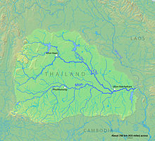
 Map of the Mun River drainage basin | |
| Native name | แม่น้ำมูล (Thai) |
| Location | |
| Country | Thailand |
| Physical characteristics | |
| Source | |
| • location | Nakhon Ratchasima |
| • elevation | 530 m (1,740 ft) |
Amphoe Khong Chiam, Ubon Ratchathani province | |
• coordinates | 15°19′14″N 105°30′29″E / 15.32056°N 105.50806°E |
• elevation | 97 m (318 ft) |
| Length | 641 km (398 mi) |
| Basin size | 119,180 km2 (46,020 sq mi) |
| Discharge | |
| • location | Mekong River, Ubon Ratchathani |
| • average | 725 m3/s (25,600 cu ft/s) |
| • maximum | 10,015 m3/s (353,700 cu ft/s) |
| Basin features | |
| Tributaries | |
| • left | Mekong River :Total: 1,162 km |
The Mun River (
Mekong River
. It carries approximately 26 cubic kilometres (6.2 cu mi) of water per year.
Geography

The river begins in the
Sisaket Province
.
History
Thanks to the
US Air Force personnel stationed at Ubon Ratchathani airbase during the Vietnam War. The spelling is still fairly common.[1]
The controversial Pak Mun Dam, which is charged with causing environmental damage,[2] is near the river's confluence with the Mekong.
Tributaries
References
External links
![]() Media related to Mun River at Wikimedia Commons
Media related to Mun River at Wikimedia Commons
